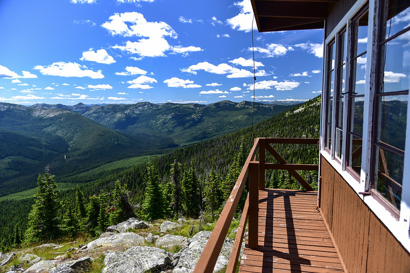
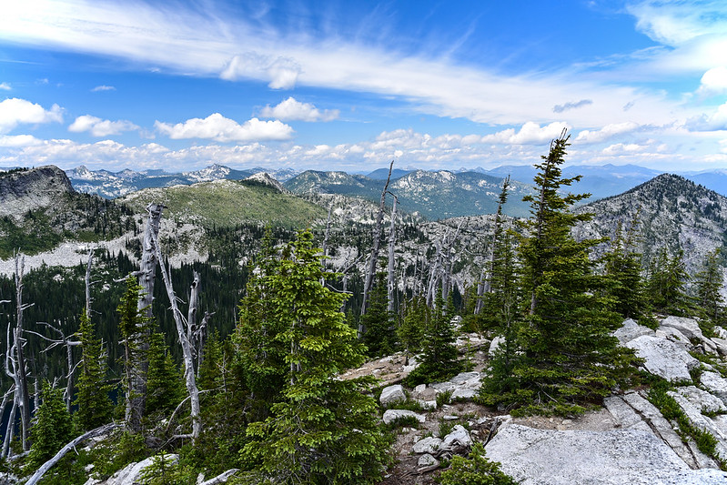
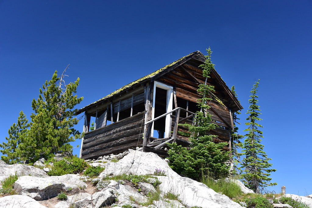
After our strenuous and failed attempt to reach Roman Nose Peak yesterday, for our last hike in the Selkirks today we did an easier hike and visited Shorty Peak, which is in northern Idaho just south of the Canadian border. Continue reading →
On the fourth day of our Selkirks trip we attempted to get to the summit of
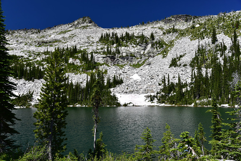
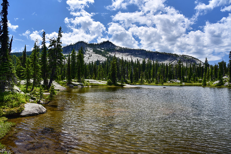
 Roman Nose Peak. Originally today we had planned to hike to West Fork Mountain but after seeing Roman Nose from the Beehive Lake area yesterday we decided to change our plans and try the off-trail route to get up there. Continue reading →
We spent several days in the Bonner’s Ferry area, doing day hikes in Idaho’s Selkirk Mountains.
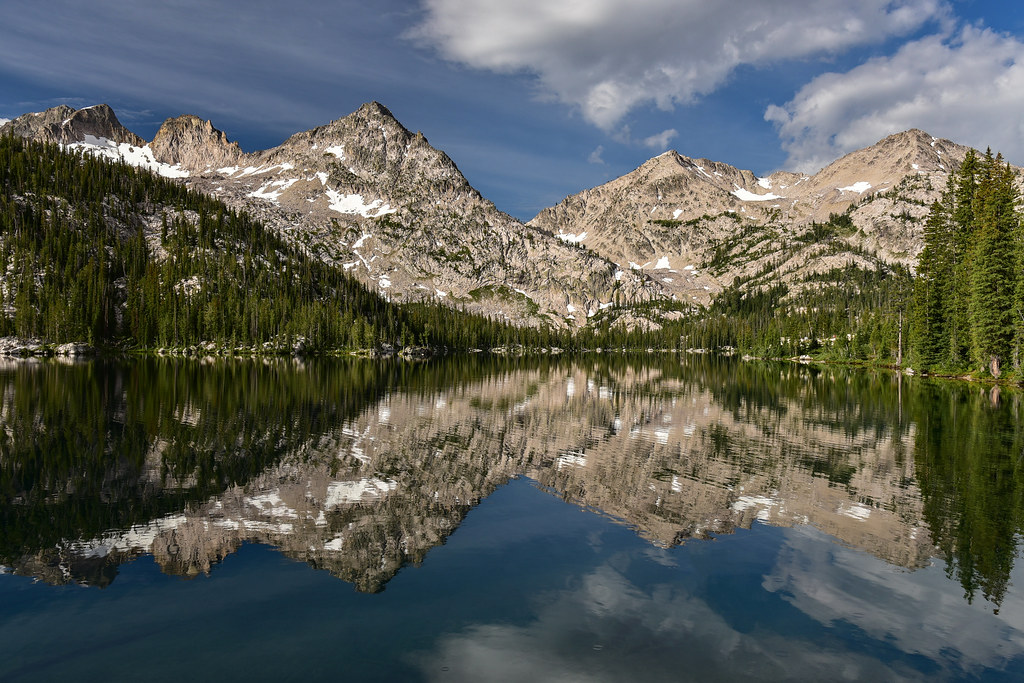
 The first hike we did was to Two Mouth Lakes. Continue reading →
I’ve been hearing about the Sawtooths for a long time. It looked like a beautiful place and it’s been on my wish list for awhile. So I moved it to the top of the list for our vacation this year, and after our stay at the McCart Lookout in the Bitterroot National Forest, we drove down to the Sawtooth National Forest, stayed the night in a campground on Tuesday, and packed up Wednesday morning for our hike.
DAY 1
It was a gorgeous day as we approached Pettit Lake:
I picked one of the most popular hikes in the whole Sawtooth Wilderness, a loop that visits Alice Lake and Toxaway Lake and is frequently referred to as the Alice-Toxaway Loop. I was amazed at how many cars we saw at the Tin Cup Trailhead on a Wednesday morning. It felt like a weekend, or a national park.
The trailhead signboard was actually well-designed and informative. Rather than a long list of rules in 10-point font (or no information at all), the most important information was presented along with photos. I was excited to see that dogs are required to be on-leash in the Sawtooth Wilderness between July 1 and Labor Day, a rule that does not exist at home in Oregon. The sign board was clear and there was even an extra leash there for people to borrow. (Unfortunately during the four days we were out there, all dogs but one were off-leash.)
After 1.1 miles we passed the wilderness boundary and the permit box:
The trail follows the north shore of Pettit Lake, with views across to McDonald Peak:
After 1.7 miles of pretty flat hiking, we started climbing and getting some dramatic views:
We stopped to admire this patch of mint:
Greg got a shot of this hummingbird, whose coloring made him blend in with the leaves:
Shortly after that we had our first creek crossing. This creek does not have a name on any map I’ve looked at, but the trail is called the Pettit Creek Trail, so that’s what I’ll call it. We changed into our crocs and waded across:
At the second creek crossing there was a log we were able to balance on:
This was a really pretty spot near that second crossing:
The mountains rose above us:
Behind us we started getting better and better views of the White Clouds:
The trail was pretty well-graded and not steep:
We saw some nice wildflowers, including this stretch of calichordis:
We passed these three huge trees growing on the slope. Trees at this elevation don’t often grow this big, so it was cool to see:
At the third creek crossing we were once again able to use rocks and logs. I almost got knocked into the water by an off-leash dog approaching from the other side who charged into the water. The owners seemed oblivious:
Look how clear that water is!
Fourth creek crossing:
I had trouble focusing on the trail beneath my feet because I kept gawking at the mountains:
The next creek crossing actually had a bridge!
Someone with an off-leash dog passed us from behind and a short while later we heard frantic barking. Then we saw horses coming around the bend. We stepped aside and let them pass:
Our sixth and final creek crossing, the fifth one without a bridge:
We passed the first of two unnamed lakes downstream of Alice Lake, which were pretty beautiful in their own right:
We made it! There’s Alice Lake!
We found a campsite towards the far end of the lake and set up our tent:
This was the view from the shore near our site:
My Sawyer Squeeze filter refused to work. (I later learned that it was because I did not backwash it first, something I should have done before the trip. Once we got home and I did that, it worked again.) Fortunately we had water treatment tablets. These take time, but were better than not filtering at all:
We were on a peninsula and I went across to the other side to get the view over there:
A panorama from the tip of the peninsula:
I found evidence of a campfire, even though they aren’t allowed here:
We sat by the lake for awhile, but it ended up being a tad too warm so we retreated to the shade of our site:
The day transitioned into a beautiful clear evening:
We had expected the mosquitoes to be really bad here, but they weren’t. They were around, for sure, but not the swarms we were expecting. We ate dinner with this as our view:
Mileage today: 6.9 miles
DAY 2
Our Alice Lake campsite was in shade for awhile this morning as we watched the sun slowly spilling down the face of the mountains:
This lake is absolutely gorgeous. This may very well be the most beautiful place I have ever camped:
After breakfast and a leisurely morning of enjoying the scenery, we hit the trail at 10:20:
We saw some nice wildflowers including Rocky Mountain Columbine:
And Nuttal’s Linanthus:
Rydberg’s penstemon:
We reached the junction where we headed to the left for Twin Lakes. If I’m reading the map correctly, this is where Pettit Creek Trail #095 ends and the Alice Lake – Redfish Lake Trail #092 begins, which we would be taking over Snowyside Pass to Toxaway Lake:
But first we descended down to Twin Lakes. It was quite peaceful here:
We hiked the isthumus between the two lakes to the other side where we discovered the most delightful gurgling snowmelt stream lined with wildflowers. Pictures don’t really do justice to how utterly charming this spot was:
While Greg continued to take pictures I set off to find the geocache, which was the reason we came over to this side of the lake in the first place. It was hidden at the base of a big old dead tree, which is in the dead center of this shot:
Better look:
Almost there:
This is the view from the tree looking down at Twin Lakes:
Can you see Greg?
Back on the main trail we continued climbing:
We had good views looking down on Twin Lakes:
We reached Snowyside Pass at 1:30. Damn, the view up there was great! There was a small patch of snow here, the first we’d encountered on the trail so far. We hiked up that trail you see on the right, and would be hiking down the other side to the left:
We had a nice view of the area we’d just left, including Twin Lakes:
And a tiny bit of Alice Lake:
This was the view down the other side, where we are headed:
Looking up at Snowyside Peak above us:
After a break we left the pass and started down the other side:
This would be a really hot shadeless ascent if we were going the other direction. But cruising downhill we were able to enjoy the gurgling snowmelt streams and wildflowers near the trail:
We passed three unnamed ponds:
The creek flowing out of the ponds eventually spilled down a smooth granite rock face that was super cool-looking:
We kept descending and then crossed that creek shortly before reaching Toxaway Lake:
Almost there:
The trail travels high above Toxaway Lake, with occasional side trails down to campsites (or not, as we discovered). It took us awhile, but we finally found a site near the water with a good view:
There were definitely more mosquitoes here than at Alice Lake, or maybe the wind was a little more subdued at Toxaway. I’m glad we treated our clothes with permethrin.
Mileage today: 6.6 miles
A note: I was very curious about the name “Toxaway.” When we got home I found this info in Matt Leidecker’s boo,k Exploring the Sawtooths:
“In 1894 scientists with the Federal Bureau of Fisheries spent three days on Alturas Lake studying salmon as part of a larger investigation of the Columbia River watershed. For the next two summers, a young biologist named Barton Everman led the Bureau’s Sawtooth studies on Alturas and Pettit Lakes.”
“The research team had several impacts on the region. Members of the party explored the canyons upstream from Alturas, Pettit, and Yellow Belly Lakes. Barton named two lakes after his young children, Toxaway and Edith (the former was named after the Toxaway River in North Carolina where Everman had taken a canoe trip several years earlier). Another member of the party was married to a woman named Alice, after whom Alice Lakes is likely named.”
DAY 3
It was a calm beautiful morning at Toxaway Lake, although the clouds were rolling in fast:
We lingered by the lake, enjoying the morning, although I could have done without the nearby kids screaming and and throwing rocks in the lock.
We passed Bowknot Lake, which has no campsites:
Then we passed Lake 8165, which was bigger and prettier than Bowknot. Why it doesn’t have a name other than its elevation, I don’t know. It had a really cool waterfall sliding down the rock into the lake:
1.6 miles past Toxaway Lake we reached the junction with the Edith Lake Trail. We didn’t have a long mileage day today, so we decided to take this little detour and headed up the hill. We spotted a woodpecker up in a tree and Greg got some good shots of it:
We crossed Edith Lake’s outflow creek several times. This was the first time:
We skirted this huge rockslide where we heard pikas but didn’t see any:
Crossing the creek again:
It was exactly half a mile up the trail to the lake. The overcast skies didn’t make for great photos, but it was a beautiful spot:
Camping isn’t allowed at Edith Lake, we discovered:
I loved this little tenacious tree:
We descended back to the Yellow Belly Trail and continued on. We crossed the foot of the huge rockslide that we had seen the top of earlier on the Edith Lake Trail:
Wildflowers:
First views of Farley Lake:
Since it was now Friday night I was a little nervous about getting a campsite at Farley Lake. We had passed dozens of people heading up to Toxaway Lake this day. Fortuantely we found a good spot with no neighbors and a nice view:
Another lake where campfires aren’t allowed and another burn scar. Looks like this one started spreading in the duff:
It had drizzled off an on all day, but around 6:30 we got a good downpour that lasted awhile. We holed up in the tent waiting for it to pass, then did our evening chores and went to bed.
Mileage today: 5 miles
DAY 4
After yesterday’s clouds and last night’s rain, morning was clear and beautiful:
Knowing this was our last morning in the backcountry, we lingered in camp until 11:30 before finally packing up and starting our hike. We had some nice views as we hiked out:
/
We crossed the remains of an avalanche from the previous winter. It was a mess of tree trunks and branches, but fortunately a path had been trampled through the snow:
Another bridgeless creek crossing:
We crossed the wilderness boundary:
This is what the last few miles looked like:
We reached the junction with the Pettit Lake Cutoff and turned onto it. Unfortunately this trail goes uphill for a full mile before crossing a ridge and descending down to the Tin Cup Trailhead. On the fourth and final day of your trip when you’ve got cold beer and hot showers on your mind, going uphill is not fun. This is the final mile as we descended to Pettit Lake:
We made it back to the car at 2:15, happy to throw down our packs and take off our boots. A storm rolled in right as we were loading up the car. Good timing!
Mileage today: 5.2 miles
Total mileage 23.7. Let’s call it 24. 🙂
We devoured our cheesy breadsticks and pizza at Papa Brunee’s in Stanley that night:
This was a GREAT trip. The scenery was spectacular and we lucked out with nice weather for three of the four days. We also lucked out with the mosquitoes, which were never terrible. I’m very glad that we did the trip clockwise. If we had done it the other way we would have been at Alice Lake on a Friday night. I imagine that Alice Lake is a total zoo on the weekends and that our experience would have been far less enjoyable with all those crowds. Passing hoards of hikers who were heading in to Toxaway Lake on Friday made me glad that we were able to do most of this trip during the week and that we were staying at one of the less popular lakes on that Friday night. The one disadvantage to doing the loop clockwise is having to go uphill there at the very end before descending back to the trailhead. That was a bit disheartening.
We fell asleep last night to the sound of crickets and an owl. So awesome! The stars were also amazing:
On the advice of our campground neighbors, Wednesday morning we drove up the Kleinschmidt Grade. This road on the Idaho side of the canyon has been around for quite awhile. It was built by entrepreneur Albert Kleinschmidt in the 1880s so he could haul copper and gold from the Seven Devils area to the Snake River. That venture didn’t pan out, but the road still exists. It’s steep and narrow in places, but it’s in good shape and is doable in a passenger car. We stopped at this lovely pullout part of the way up. The landscape and vegetation changes pretty quickly as you climb up and away from the canyon:
Before driving up to the Lynes communication tower we checked out the little community of Cuprum, which seemed to mostly consist of vacation cabins and a handful of year-round residences. According to Donald C. Miller’s 1976 book Ghost Towns of Idaho, “Cuprum was in the Seven Devils Mining District, about twenty-eight miles northwest of Council, located among still reportedly immense, untapped copper deposits. The town still exists, but as a logging and summer cabin settlement, rather than as a mining town.”
Then we drove up the road to the communication tower. This two-mile stretch was pretty rough and rutted. The Outback probably could have made it, but I was glad we had the truck. It was DEFINITELY worth the drive up, because the 360 degree views were spectacular!
Some of Idaho’s mountains to the southeast:
The communication tower (we had a great phone signal up here):
The Wallowa Mountains to the west:
Looking south down into the canyon:
Mountains directly to our north:
The phlox was blooming like crazy up there:
We could just make out the lookout on nearby Horse Mountain:
Looking back at the road we drove to the summit:
We soaked up the views, looked at things through the binoculars, identified mountains with the PeakFinder app, and generally just enjoyed the scenery. It was beautiful and sunny with only a bit of a breeze. After hanging out up there for awhile we headed back down. I shot this picture of the river on the way down, which shows the green Idaho side and the less-green Oregon side:
Looking down on our campground from the road above:
After a bite to eat at our campsite, we drove up the riverside road to the Hells Canyon Dam. It’s actually quite a scenic drive this time of year! Once we reached the dam we drove across it to the Oregon side and parked at the visitor center.
Idaho Power operates this dam along with Brownlee Dam and Oxbow Dam. The original dam proposal was for one 710-foot-high dam with a reservoir that would have extended 89 miles upstream. But that plan was abandoned and the three smaller dams were built instead. The dams were built without fish passages. According to the Native Fish Society, “The Snake River was once one of the most important rivers for the spawning of anadromous fish-—which are born in the headwaters of rivers, live in the ocean for most of their lives, and return to the river to spawn-—in the United States. The river supported species including chinook salmon, coho salmon, and sockeye salmon, as well as steelhead, white sturgeon, and Pacific lamprey. It is known that before the construction of dams on the river, there were three major chinook salmon runs in the Snake River; in the spring, summer and fall, totaling about 120,000 fish, and the sockeye salmon run was about 150,000. The historical barrier to fish migration on the Snake River was Shoshone Falls, a waterfall that occurs as the Snake River passes through the Snake River Plain.”
At a picnic shelter near the visitor center I heard squeaking. I looked up and there were a bunch of bats roosting up there. Cool!
There is a mile-long riverside trail on the Oregon side and we meandered down that way:
This jumble of rocks is known as Rush Creek Rapids, the remains of an enormous 400-foot-high landslide 10-15 thousand years ago. Wow!
Looking back at the dam:
I think we encountered more poison ivy on this hike than all our other hikes this trip:
It was pretty cool to see the Snake River as a river and not a reservoir. We stopped at a big flat rock with a fine view and stayed to soak up the view for awhile. It was incredibly beautiful!
We hiked back to the truck and drove back across the dam to the Idaho side. On that side is the Deep Creek Stairway, which was built in 1989 to provide safe river access for Idaho anglers.
It’s a crazy stairway, going up, over, and around the rocky cliff face. I hoped it had passed inspection in the recent past:
At a muddy spot on the trail we saw a bunch of butterflies:
And here’s the view of the 330-foot dam from below:
We made the scenic drive back to the campground where we enjoyed a calm windless evening. All we could hear were the birds and crickets. It was so peaceful. New neighbors arrived at about 8:15. It looked like they were grandparents with their young grandkids. They had this massive old-fashioned canvas tent that must have been hell to put up. But at least they were quiet neighbors.
Last Monday Deb and I drove from Portland out to Hells Canyon. We scoped out Hells Canyon Park as a possible campground and decided to stay. It’s run by Idaho Power and is not set up like a traditional campground with individual sites that each have their own little driveway. The tent area was a big grassy area with trees and picnic tables and site numbers and you had to walk a short distance from your vehicle. No worries. It totally worked for us.
Monday evening we saw some Canada Geese and their fuzzy goslings. Cute!
The campground is situated on the Snake River, but since this spot is upstream of the Hells Canyon Dam the river is actually a reservoir at this point.
It got pretty cold Monday night and I could not get warm even in my toasty sleeping bag. I put my hiking pants on over my long johns, along with four layers on my torso (one of which was my down jacket), and then I finally was able to sleep!
Tuesday morning was VERY VERY windy. Even with our wind-blocking efforts it took half an hour to boil water for tea because the burner on the gas stove was so wind-blown.
We decided to hike up Eckels Creek, traverse north on the Kinney Creek Trail, then descend on the Allison Creek Trail. We hit the trail at 9:40 and started hiking up. We were surprised by how green it was here!
We saw quite a few wildflowers:
The trail left the high slopes and got closer to the creek. This section was extremely brushy.
It was a relief to leave behind the brushy creek canyon and climb back up to the meadowy slopes. at 11:30 we stopped for a break at those trees ahead.
Looking back down:
The trail kept climbing a bit more until we reached a junction with the Kinney Creek Trail, which travels north while traversing the open slopes high above the Snake River. There was a spiffy new-looking sign at the junction. The junction, by the way, is in the wrong spot on the topo map.
The Kinney Creek Trail was pretty spectacular and we passed through fields of wildflowers while also getting great views of Hells Canyon. The weather turned overcast and very windy for awhile along this stretch.
We left the Kinney Creek Trail at another well-signed junction.
From that junction we had pretty nice views of the mountains rising to the east.
Then we began the long descent back down to the road.
We hiked through more wildflowers.
And we got a view of a cave we would pass once we got down further.
The cave is in a big limestone outcropping known as The Flatiron.
Descending to Allison Creek we entered more brushy areas, but it wasn’t nearly as bad as the sections along Eckels Creek had been.
Once we got to the cave, a short side trail led to the entrance.
Deb decided to explore.
From there we were quickly back to the road, albeit at a different trailhead. We briefly checked out the Big Bar campground across the road from the Allison Creek Trailhead. There were a few RVs, but it was pretty quiet. There’s a little boat ramp into the reservoir.
It was less than a mile to walk back to the Eckels Creek Trailhead where we had parked. Along the way we passed an interpretive sign and a gravesite. The sign explained that the graves were those of Archibald Ritchie and John Eckles, who had an orchard at the site that is now the Big Bar Campground in the late 1800s.
We were camped next to a very nice and friendly couple from Boise and they had told us when they hiked a ways up the Eckels Creek Trail they had picked up quite a few ticks on their clothes. We were super paranoid about this and tucked our pant legs into our socks and our shirts into our pants. The only tick we saw the whole time was one on Deb’s pants when were at the cave. Other than that, no ticks. There was LOTS of poison ivy on this hike and it’s so ubiquitous that it’s totally impossible to avoid. Long pants and long sleeves are highly recommended.