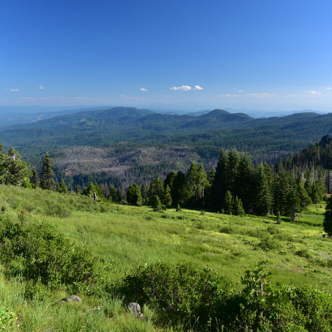
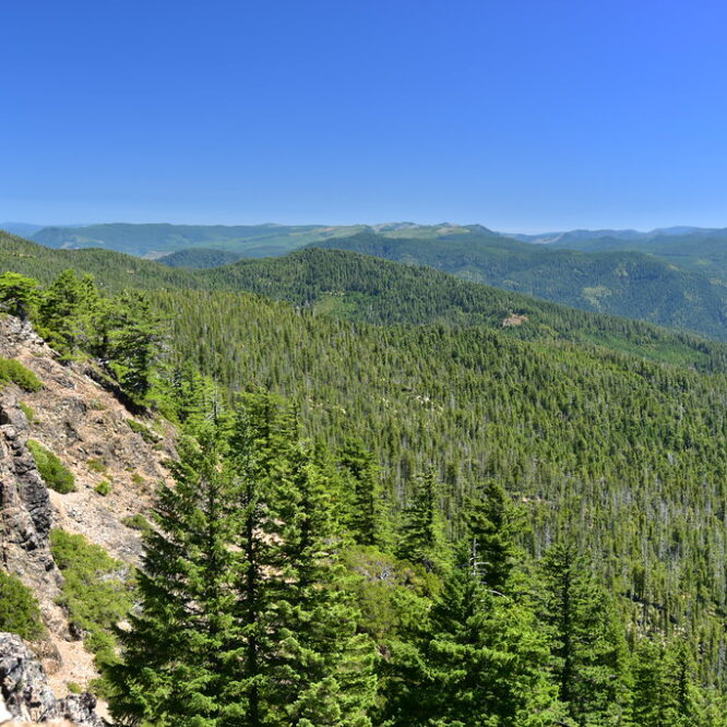
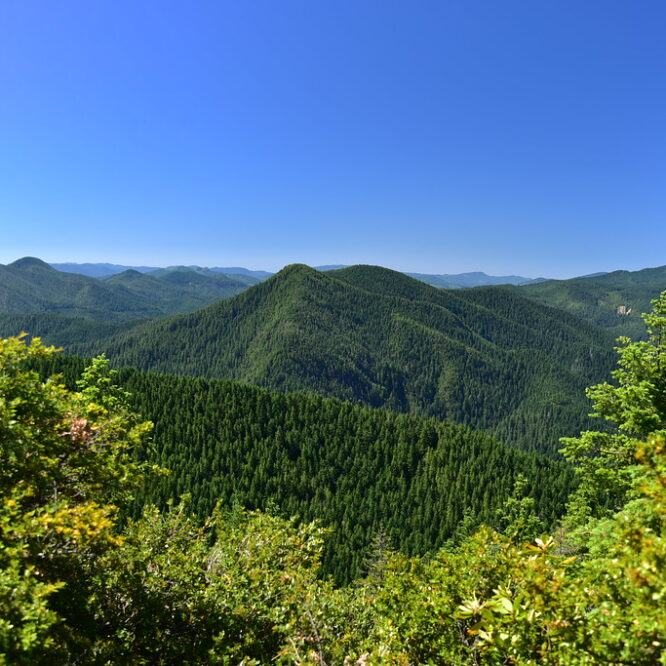
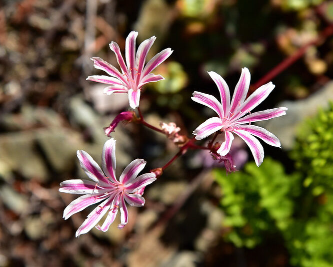
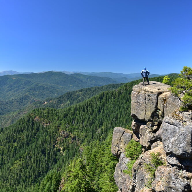
Friday, June 10 – Sunday, June 12, 2022
The wet spring continues. With an atmospheric river and A LOT of rain affecting much of the state, I headed to southern Oregon to try and find some dry weather. Continue reading
Friday, June 10 – Sunday, June 12, 2022
The wet spring continues. With an atmospheric river and A LOT of rain affecting much of the state, I headed to southern Oregon to try and find some dry weather. Continue reading
Saturday June 19, 2021
After yesterday’s incredibly long hike to Pearsoll Peak I was somehow up for another hike today and decided to do Eagle Mountain. Continue reading
Friday, June 18, 2021
Today as part of my goal to visit every publicly-accessible lookout in Oregon I visited Pearsoll Peak. It was not an easy journey. Continue reading
Friday, July 3, 2020
Today we did a loop hike involving both of the Tanner Lakes as well as Tanner Mountain, all of which lie inside the Red Buttes Wilderness. Continue reading
Wednesday, July 1, 2020
On our way to stay at Bolan Mountain lookout for a long 4th of July weekend we made a detour up Road 4201 to the Babyfoot Lake Trailhead. Continue reading
Saturday, July 6, 2019
We stayed at the Squaw Peak Lookout in the Siskiyous over the holiday weekend (read more about that here). After hitting the road to the trailhead first thing in the morning the previous two days, this morning we decided to take it easy and relax. After some relaxation time we did a nearby hike on Little Grayback Mountain.
Most people who do this hike probably start at the lower trailhead. We parked at the upper trailhead on Road 340 since it was much closer:
Motorcycles are unfortunately allowed on this trail. This small trailhead sign claimed that the trail was maintained by the Motorcycle Riders Association, but it didn’t look to us like the trail had been maintained in a few years:
At this spot where a tree fell across the trail, the motorcycles just gouged a new trail up the hill to go around the tree:
The trail does not go to (or near) the summit, but traverses the slopes on the south side:
The trail alternated between open meadow areas…
…and pleasant shady forest:
At this elevation most of the wildflowers finished blooming about a month ago, but there were still a few left:
Oregon sunshine
Cobweb thistle
Coyote mint
Grand collomia
We also some poison oak:
At the two-mile mark we passed some big boulders in the shade that looked like a good spot for a break:
Then we turned and headed back, enjoying the views along the way:
That’s Dutchman Peak on the left:
There are some nice big trees here:
Little hiker, big landscape:
Our total for the day was 4 miles, 480′ elevation gain. Back at the lookout that evening we enjoyed a wine and cheese “appetizer” before dinner. Great way to finish the day!
Then watched an amazing sunset on our final night:
Friday, July 5
We stayed at the Squaw Peak Lookout in the Siskiyous over the holiday weekend (read more about that here). After hiking in the vicinity of Big Red Mountain the day before, we had planned to do a hike closer to the lookout today, then head back over to the Siskiyou Crest area again on Saturday. But Greg discovered that he left his trekking poles at the trailhead yesterday, so we moved our Saturday plans to today so we could go look for them. Fortunately they were right where he left them at Wrangle Gap so after picking them up we headed to 7,417′ Dutchman Peak (often mistakenly referred to as Dutchman’s Peak).
We were able to drive up Road 800 for 0.8 mile, then we parked at the gate to walk the final half mile to the top:
Normally it’s not ideal to have to road walk to a lookout, something we have done plenty of. It’s nice when you can drive all the way to the top. But in this case it was fine because it was a very pretty road walk. It was totally open and the views were great:
And there were lots of wildflowers:
Plenty of pollinators around too:
There was a bit of snow on the north side:
The lookout is still used in emergencies, but it was unstaffed during out visit and surprisingly was unlocked!
There is even a visitor’s log:
The views from the top were great. Looking west:
The peak right in the center with the bald south face is Squaw Peak (Baldy Peak is at far right):
Mt. Shasta to the south. Not as clear today as yesterday!
View of Mt. Ashland to the northeast:
Looking southwest, with Observation Peak on the left:
Silver Fork Basin with Observation Peak on the right:
We short-cutted back to Road 20 via Road 805, where we encountered even more flowers:
The car sure is getting dusty!
Next up was a hike up to Observation Peak via the PCT. According to Luke Ruediger in The Siskiyou Crest, “Observation Peak represents a hot spot for botanical diversity, harboring many rare plant species on its varied bedrock and soil types.” Sounds like our type of place!
We could have started this hike at Jackson Gap, but we opted for a slightly longer route. We drove back down Road 20 to Silver Fork Gap where we picked up Road 2025 and drove four miles south to a spot where the PCT crosses the road, and started hiking north:
We reached the grassy lower slopes of Observation Peak:
Then got off the trail and headed cross country to the summit:
Looking back along our route, with Dutchman Peak right of center:
View of Dutchman peak and the terraced slopes of Silver Creek Basin. This entire area was once so thick with livestock that “fire lookouts in the area were trained to differentiate between the smoke of fires and the massive dust storms created by overgrazing on the Siskiyou Crest” (according to Luke Ruediger in The Siskiyou Crest). The terracing on the slopes here was done in the late 1950s to slow the erosion caused by that livestock grazing.:
This is the 7,340′ summit:
That red can contained the summit register, but the logbook was soaking wet and moldy:
I’ve never seen a survey disc like this one before:
There was a normal-looking survey disc as well:
The views were pretty expansive. Looking southwest:
Looking west:
Looking north, with Mt. Ashland on the right:
Looking southeast to Mt. Shasta:
Panorama from NE to SE, with Cow Creek Glade directly below:
A better look at Cow Creek Glade:
This spot is not remote, by any means. We could see Road 20 to the north, and Road 40S01 was just 400 feet down the steep east-facing slope from where we sat. But we only saw three or four cars the whole time, and the only other hiker up there left soon after we arrived. After enjoying the beautiful and peaceful setting we turned and headed back. Greg took these shots of me on the way down:
Hiking the trail back to the car we met a backpacker who was on her first day of an Oregon PCT thru-hike, with her husband joining her for the first segment. She was VERY excited, and her enthusiasm for the trek ahead was endearing.
Total mileage for the hike was 5.3 miles, 1,100′ elevation gain.
Thursday, July 4, 2019
We stayed at the Squaw Peak Lookout in the Siskiyous over the holiday weekend (read more about that here) and on the 4th we decided to drive over to the Siskiyou Crest area and visit Big Red Mountain, which is thought to be the oldest exposed serpentine outcrop in the Siskiyous, according to Luke Ruediger (whose excellent book, The Siskiyou Crest, is a must-have guide for visiting this area.)
According to the Forest Service, Big Red Mountain “gets its name from the reddish orange soil and rock; this color is caused by the weathering of iron in the peridotite and serpentine bedrock. The unusual chemical make-up (low calcium/high iron and magnesium) of serpentine soil is toxic to many kinds of plants. Because of this, places like Red Mountain support a distinctive plant community dominated by Jeffrey pine, western white pine, and incense-cedar over a ‘carpet’ of beargrass.”
We encountered snow on Road 20 at Jackson Gap, just north of the junction with Road 800 up to Dutchman Peak. This looks like it would have been impassible about a week ago, but we had no problem today:
We continued up Road 20 and parked at Wrangle Gap, where there is an old mangled sign:
The PCT here swings north to go around Big Red Mountain, but we were headed cross-country straight up. While Greg was getting his stuff together at the car, I started up. Right away I got great views of Mt. Shasta:
Looking back down at Greg on Road 20:
We saw all sorts of wildflowers on the mountain and along the trail later. Siskiyou Paintbrush:
Lewisia leana:
Anemone:
Phlox:
Mountain owl clover:
Greg was in wildflower heaven and this was his stance for much of the day:
The top of Big Red Mountain is a pretty large area:
And of course the views were great up there. We didn’t know it, but this would be the clearest day of our trip and we could see for miles. Sure beats last year when we arrived at the Mt. Ashland campground and were surrounded by wildfire haze. Looking west:
Looking southwest; that’s Road 20 left of center, and Dutchman Peak on the right:
Looking south to Mt. Shasta, and the snowy Trinity Alps on the right:
Looking north, with distant Mt. McLoughlin on the left and Mt. Ashland on the right:
Close-up of Mt. Ashland and it’s big ugly weather ball:
Greg was being thorough and methodical in his wildflower documentation, so I descended the north side of the mountain while he kept taking photos. There were still patches of snow on this side:
There was a bit of beargrass on the PCT:
But it looks like last year or the year before was the banner beargrass year here, based on all the dried up flower stalks we saw:
Greg descended and we hiked north along a very pretty stretch of the PCT:
We had a good view of Wagner Butte, which we hiked last July:
There were some trees along this stretch, but a lot of it was pretty open:
The trail lost elevation as it headed toward Siskiyou Gap. We knew this would be the case, but we hadn’t wanted to drive the three extra miles of Road 20 to park at Siskiyou Gap and start the hike from there, since those three miles are reportedly very rough. We reached the trailhead at Siskiyou Gap:
There was a view of Mt. Shasta here:
After a break we turned and headed back, trudging uphill in the afternoon heat:
This time we went around Big Red Mountain on the trail instead of over it. We passed a spot where we could see down on the tiny Monogram Lakes:
This is a panorama from that same spot, looking north. Wagner Butte at center:
A cold beer with chips and salsa really hit the spot after our hike!
Our total for the day was 6.7 miles with 1,400′ elevation gain. Tomorrow we would be back in this area to visit Dutchman Peak and Observation Peak.
Back at the lookout that evening we celebrated our wedding anniversary with pesto pasta and white wine. Our anniversary was yesterday, but we postponed our celebration to tonight since we rolled in so late last night. Eating out at a nice restaurant is fun, but I think this is the best way for two outdoor-lovers to celebrate:
Sunday, May 26, 2019
Today was forecast to be the cloudiest weather day of our long weekend, so rather than hike we drove the T.J. Howell Botanical Drive which encompasses about 7.5 miles of Eight Dollar Road / Road 4201. The Forest Service has a brochure and a plant list on their website. This description from the Forest Service site best sums up the area:
Approximately 7.5 miles of the Eight Dollar Road is designated as The TJ Howell Botanical Drive. The drive passes predominately through the Josephine Ophiolite, a large chunk of upper mantle and oceanic crust that has been shoved up above sea level, exposing ultramafic serpentine and its parent rock, peridotite. Part of the Klamath-Siskiyou Mountains, this location is one of the largest serpentine areas in North America.
Only plant species that can tolerate extreme conditions grow here. Thin soils, heavy metals (magnesium, nickel, chromium, iron), and nutrient stress (low amounts of calcium and nitrogen) make these serpentine soils inhospitable. Many unusual, rare, or endemic species have evolved under these conditions, while other plants have special adaptations for survival, or exist in stunted form.
We drove Highway 199 out of Grants Pass. Our first stop was the Eight Dollar Mountain boardwalk:
The end of the boardwalk is missing its sign:
It overlooks a darlingtonia fen:
Darlingtonia californica is also known as the California pitcher plant, cobra lily, or cobra plant. It is carnivorous, trapping insects and absorbing their nutrients.
Next up was the Little Falls Loop:
This was Greg’s typical pose all day, identifying wildflowers:
We saw some wildflowers on this loop:
The trail took us down to the Illinois River:
This is Little Illinois River Falls, otherwise known as Little Falls. It’s not so much a waterfall as a narrow chute where the water runs fast:
This is what the river looks like upstream from there:
Then we continued upstream:
Back at the car we continued down the road to a pull-out across from where Josephine Creek flows into the river. That wasn’t so interesting, but across the road was a nice little fen with Darlingtonia. Dang, they are weird-looking plants!:
This is what their flowers look like:
In this spot we also saw some very pretty Siskiyou Indian Paintbrush:
Our next stop was the bridge over the river, which unfortunately has been the victim of a lot of graffiti. We got out to look around and admire the river:
Our next stop was the Days Gulch Botanical Area. You have to know it’s here as there are no signs. Someone had trashed the parking area with a trash-filled campfire:
We spotted what look like maybe a hunter’s camp in the trees:
This area is the location of a long-term study of the Howell’s mariposa lily, although we didn’t see any. We did see other flowers though:
They have fenced this area off in order to keep out OHVs:
Out next stop along the road was to visit this huge Darlingtonia fen:
Further along we stopped to find a geocache and we were treated to a nice viewpoint:
There’s the bridge we stopped at earlier:
We could see the scars from last year’s Klondike Fire:
The brochure mentioned white bleeding heart at milepost 6 and sure enough we saw some along the road:
Although the road keeps going, the Botanical Drive officially ends after 7.4 miles where there is a gravel parking area with a picnic table and an old broken sign.
We decided to park here and try to find a nearby geocache, which had parking coordinates here. We headed for the trees across the road:
And followed this old road:
We saw this cool California ground-cone (Boschniakia strobilacea):
We left the old road where this old wooden sign indicated a trail:
The trail was clearly disused, but still easy to follow. Unfortunately there was some poison oak:
And then we emerged from the trees and climbed up this knoll:
And at the top we discovered two random picnic tables!
When we got home I checked old maps and could not find this viewpoint or trail marked on any of them. Can’t help but wonder what the story is. Anyway, the view from up there was pretty good:
For the return route we wanted to avoid the poison oak on the abandoned trail, so Greg decided we would drop down to the saddle below the knoll:
And then drop down this steep slope to the road below:
Beargrass:
We road-hiked back to the car and enjoyed the view there for awhile before driving back to Grants Pass:
We went back to The Haul for dinner and enjoyed their fabulous churros:
Great day!
Sunday, May 5, 2019
Our first stop this morning was the New River Nature Center. We could find no information about its hours online and there was no recording at the number that’s listed for it. So we took a gamble. When we arrived around 9:15 the place was locked up with no posted hours. A volunteer was inside and heard us. It turned out the place didn’t open until 10am, but he opened the door and let us in to have a look around. He sure was a chatty fellow!
Do you see the resemblance?
We went down to the boat ramp to see the New River, so-called because an 1890 flood created this miles-long “moat” paralleling the ocean:
Then we drove south down to the Gold Beach area, and drove inland a bit into the Rogue River-Siskiyou National Forest to hike the short Frances Shrader Old Growth Trail, dedicated to Frances Shrader, a long-time employee of the Forest Service who was instrumental in developing plans for this trail:
As the name of this trail implies, there are some huge Douglas Fir and Port Orford Cedar in here:
This is a scar from a very very old trail blaze:
Our next stop was the nearby Myrtle Tree Trail:
This is the largest myrtlewood tree in the world!
We drove into Lobster Creek Campground, right next to where Road 3310 crosses over the Rogue River. There’s a boat ramp here and a huge gravelly beach. It was pretty quiet here today, but I bet it’s very busy in the summer:
After lunch in Gold Beach, our next stop was the Cape Sebastian State Scenic Corridor. (The name comes from Sebastian Vizcaino, who explored this area in 1602 on behalf of Spain.) This park has the distinction of having the highest overlook reachable by car on the south coast. We parked in the south lot, where we would normally have views, but today it was totally socked in, even though it had been beautiful and sunny just a few miles north in Gold Beach:
We hiked the trail south (described here):
Red lichen on the cliffs:
The trail started descending and in addition to some poison oak we saw lots of these pretty purple flowers (I believe they are Blueblossom ceanothus):
We continued to descend down, down, down:
The rock here is pockmarked, which is known as tafoni:
The trail continued on to Hunters Cove (named for the 19th century hunters who killed sea otters for their pelts):
Now we can see the beach at Hunter’s Cove:
The trail kind of peters out above the beach and you have to scramble down a crumbly slope with the aid of a rope. This is Deb climbing back up when we left:
Hunter’s Cove is big and lonely. We walked a short distance on the beach, which was completely deserted:
Cool tilted rocks in the sand:
The high tide line goes right up to the base of the cliff, so it’s good we didn’t visit during high tide!
Hunter’s Island looked like a hippo:
Looking south toward Cave Rock and Meyers Creek. If we had the time and inclination we could have hiked on the beach all the way down there:
We scrambled back up to the trail and got one last view of Hunter’s Cove before starting our hike back up to the car:
As we reached the top of the headland and the parking area the clouds FINALLY started burning off and revealing views to the north:
We could see north to Gold Beach, and the distant silhouette of Humbug Mountain: