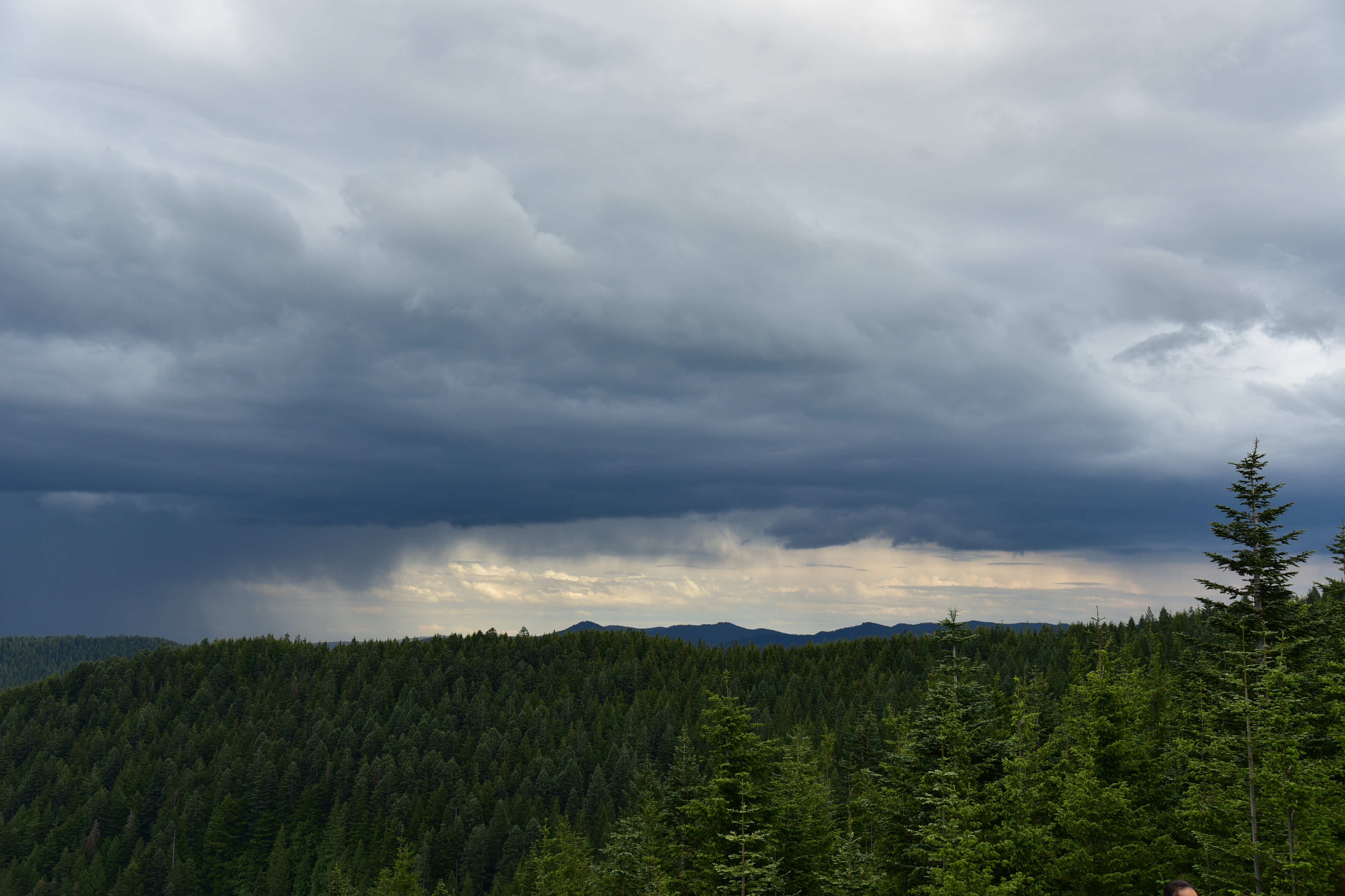
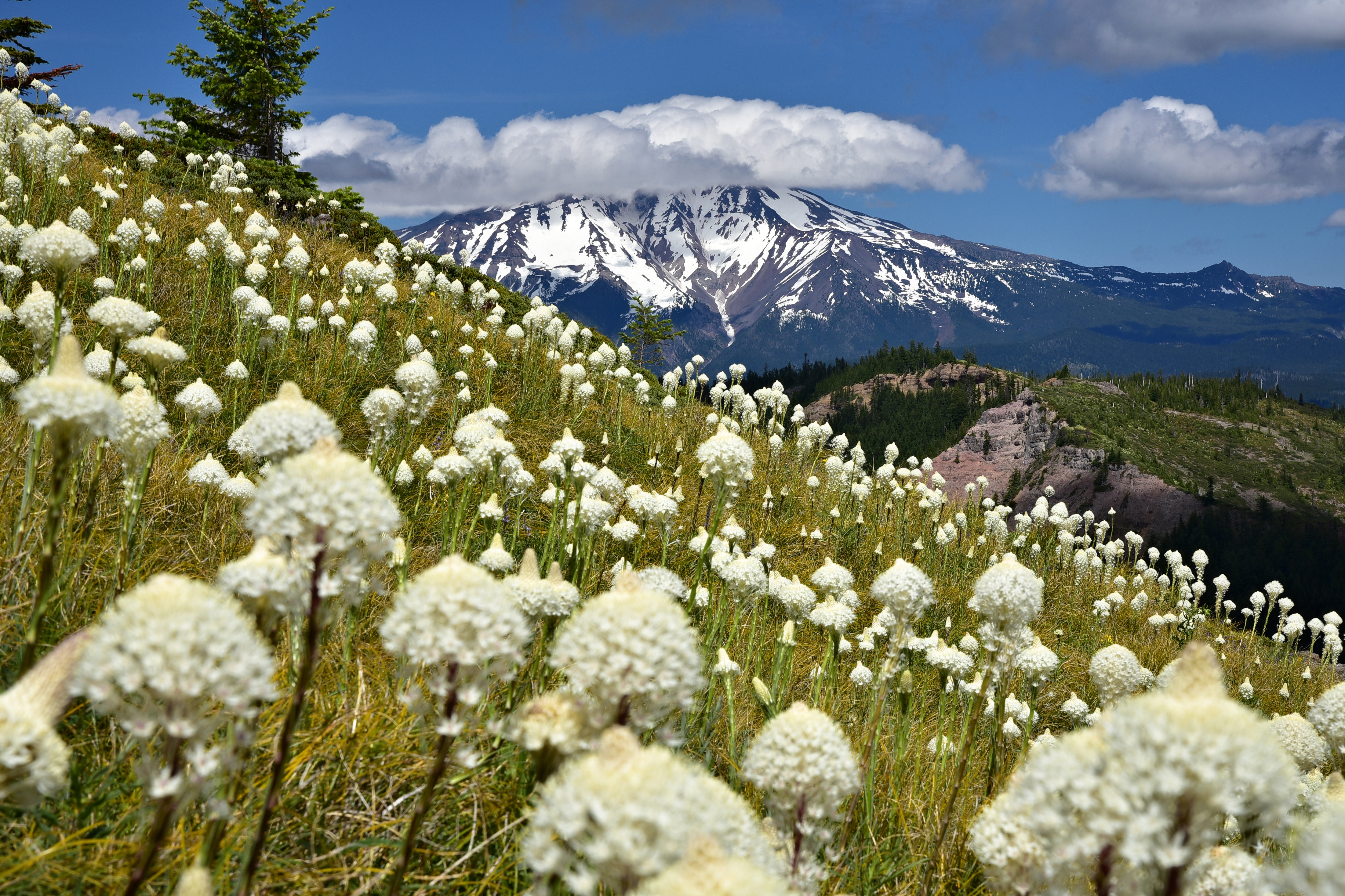
Storm-Watching on McIntyre Ridge

The McIntyre Ridge Trail has a “musical chairs” history when it comes to access. The original trailhead at the end of Road 110 (on BLM land) was closed, and an unofficial trailhead was established at the end of Road 108. Once Trailkeepers of Oregon helped build the new Douglas Trailhead the Forest Service claimed to close off access to Road 108.

Greg and I visited on June 29 and it didn’t look like access had ever been closed to Road 108. The road itself is a bit of a mess with enormous potholes. But it is open, so this is just a quick report to let you know you can still access McIntyre Ridge this way (here’s the hike description).

The boulders at the end of the road are no deterrent for the OHV crowd. They just drive around:

The first mile is not so much a trail as a road, due to the OHV use (even though this is inside the Salmon-Huckleberry Wilderness):

At the first viewpoint Mt. Hood was only partially visible:

It was not a banner beargrass year here:

But the rhododendrons were in bloom and looking nice:

And the wildflowers near the bench looked great:

McIntyre Ridge Hike

We even saw a hummingbird:

McIntyre Ridge Hike

You can still sit on the bench, but it has really reclined over the years:

McIntyre Ridge Hike

We watched (and listened to) a crazy thunderstorm moving from south to north, engulfing Mt. Hood (and dumping a bunch of hail, from what we heard):

McIntyre Ridge Hike

On the way back we spotted this shot-up handle on a tree branch. Maybe it was once part of a growler? We removed it and packed it out.

The last view of the mountain before heading back into the trees for good was a stormy one:

McIntyre Ridge Hike

Greg was about ten minutes behind me and when he got to that spot there was a cool rainbow!

McIntyre Ridge Hike

We stopped at the Douglas Trailhead on the drive out. Ever wondered what one of those new plastic-like trailhead signs looks like after being used for target practice? Wonder no more:

Little Grayback Mountain

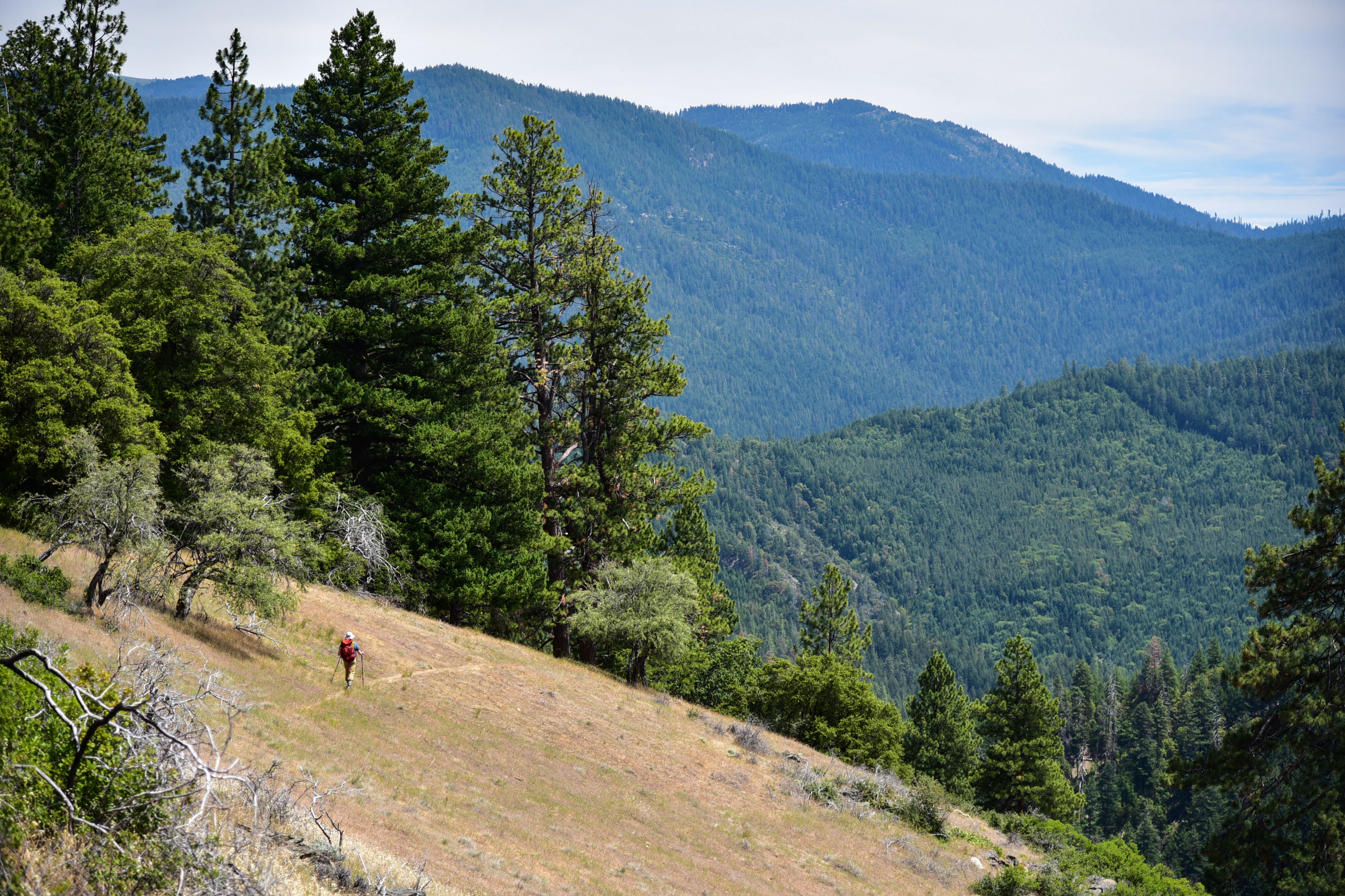
Saturday, July 6, 2019

We stayed at the Squaw Peak Lookout in the Siskiyous over the holiday weekend (read more about that here). After hitting the road to the trailhead first thing in the morning the previous two days, this morning we decided to take it easy and relax. After some relaxation time we did a nearby hike on Little Grayback Mountain.

Most people who do this hike probably start at the lower trailhead. We parked at the upper trailhead on Road 340 since it was much closer:

Little Grayback Upper Trailhead

Motorcycles are unfortunately allowed on this trail. This small trailhead sign claimed that the trail was maintained by the Motorcycle Riders Association, but it didn’t look to us like the trail had been maintained in a few years:

Little Grayback Hike

At this spot where a tree fell across the trail, the motorcycles just gouged a new trail up the hill to go around the tree:

Little Grayback Hike

The trail does not go to (or near) the summit, but traverses the slopes on the south side:

Little Grayback Hike

The trail alternated between open meadow areas…

Little Grayback Hike

Little Grayback Hike

Little Grayback Hike

…and pleasant shady forest:

Little Grayback Hike

Little Grayback Hike

At this elevation most of the wildflowers finished blooming about a month ago, but there were still a few left:

Little Grayback Hike
Oregon sunshine

Little Grayback Hike
Cobweb thistle

Little Grayback Hike
Coyote mint

Little Grayback Hike
Grand collomia

We also some poison oak:

Little Grayback Hike

At the two-mile mark we passed some big boulders in the shade that looked like a good spot for a break:

Little Grayback Hike

Then we turned and headed back, enjoying the views along the way:

Little Grayback Hike

That’s Dutchman Peak on the left:

Little Grayback Hike

There are some nice big trees here:

Little Grayback Hike

Little hiker, big landscape:

Little Grayback Hike

Little Grayback Hike

Our total for the day was 4 miles, 480′ elevation gain. Back at the lookout that evening we enjoyed a wine and cheese “appetizer” before dinner. Great way to finish the day!

Squaw Peak Lookout

Then watched an amazing sunset on our final night:

Squaw Peak Sunset

Dutchman Peak and Observation Peak

Friday, July 5

We stayed at the Squaw Peak Lookout in the Siskiyous over the holiday weekend (read more about that here). After hiking in the vicinity of Big Red Mountain the day before, we had planned to do a hike closer to the lookout today, then head back over to the Siskiyou Crest area again on Saturday. But Greg discovered that he left his trekking poles at the trailhead yesterday, so we moved our Saturday plans to today so we could go look for them. Fortunately they were right where he left them at Wrangle Gap so after picking them up we headed to 7,417′ Dutchman Peak (often mistakenly referred to as Dutchman’s Peak).

We were able to drive up Road 800 for 0.8 mile, then we parked at the gate to walk the final half mile to the top:

Dutchman Peak

Dutchman Peak

Normally it’s not ideal to have to road walk to a lookout, something we have done plenty of. It’s nice when you can drive all the way to the top. But in this case it was fine because it was a very pretty road walk. It was totally open and the views were great:

Dutchman Peak

Dutchman Peak

And there were lots of wildflowers:

Dutchman Peak

Dutchman Peak

Dutchman Peak

Dutchman Peak

Dutchman Peak

Dutchman Peak

Plenty of pollinators around too:

Dutchman Peak

There was a bit of snow on the north side:

Dutchman Peak

The lookout is still used in emergencies, but it was unstaffed during out visit and surprisingly was unlocked!

Dutchman Peak

Dutchman Peak

Dutchman Peak

Dutchman Peak

Dutchman Peak

There is even a visitor’s log:

Dutchman Peak

The views from the top were great. Looking west:

Dutchman Peak

Dutchman Peak

The peak right in the center with the bald south face is Squaw Peak (Baldy Peak is at far right):

Dutchman Peak

Mt. Shasta to the south. Not as clear today as yesterday!

Dutchman Peak

View of Mt. Ashland to the northeast:

Dutchman Peak

Looking southwest, with Observation Peak on the left:

Dutchman Peak

Silver Fork Basin with Observation Peak on the right:

Dutchman Peak

We short-cutted back to Road 20 via Road 805, where we encountered even more flowers:

Dutchman Peak

Dutchman Peak

The car sure is getting dusty!

Dutchman Peak

Next up was a hike up to Observation Peak via the PCT. According to Luke Ruediger in The Siskiyou Crest, “Observation Peak represents a hot spot for botanical diversity, harboring many rare plant species on its varied bedrock and soil types.” Sounds like our type of place!

We could have started this hike at Jackson Gap, but we opted for a slightly longer route. We drove back down Road 20 to Silver Fork Gap where we picked up Road 2025 and drove four miles south to a spot where the PCT crosses the road, and started hiking north:

Observation Peak Hike

Observation Peak Hike

Observation Peak Hike

Observation Peak Hike

We reached the grassy lower slopes of Observation Peak:

Observation Peak Hike

Then got off the trail and headed cross country to the summit:

Observation Peak Hike

Observation Peak Hike

Looking back along our route, with Dutchman Peak right of center:

Observation Peak Hike

View of Dutchman peak and the terraced slopes of Silver Creek Basin. This entire area was once so thick with livestock that “fire lookouts in the area were trained to differentiate between the smoke of fires and the massive dust storms created by overgrazing on the Siskiyou Crest” (according to Luke Ruediger in The Siskiyou Crest). The terracing on the slopes here was done in the late 1950s to slow the erosion caused by that livestock grazing.:

Observation Peak Hike

Observation Peak Hike

This is the 7,340′ summit:

Observation Peak Hike

That red can contained the summit register, but the logbook was soaking wet and moldy:

Observation Peak Hike

I’ve never seen a survey disc like this one before:

Observation Peak Hike

There was a normal-looking survey disc as well:

Observation Peak Hike

The views were pretty expansive. Looking southwest:

Observation Peak Hike

Looking west:

Observation Peak Hike

Looking north, with Mt. Ashland on the right:

Observation Peak Hike

Looking southeast to Mt. Shasta:

Observation Peak Hike

Panorama from NE to SE, with Cow Creek Glade directly below:

Observation Peak Hike

A better look at Cow Creek Glade:

Observation Peak Hike

This spot is not remote, by any means. We could see Road 20 to the north, and Road 40S01 was just 400 feet down the steep east-facing slope from where we sat. But we only saw three or four cars the whole time, and the only other hiker up there left soon after we arrived. After enjoying the beautiful and peaceful setting we turned and headed back. Greg took these shots of me on the way down:

Observation Peak Hike

Observation Peak Hike

Hiking the trail back to the car we met a backpacker who was on her first day of an Oregon PCT thru-hike, with her husband joining her for the first segment. She was VERY excited, and her enthusiasm for the trek ahead was endearing.

Total mileage for the hike was 5.3 miles, 1,100′ elevation gain.

Big Red Mountain

Thursday, July 4, 2019

We stayed at the Squaw Peak Lookout in the Siskiyous over the holiday weekend (read more about that here) and on the 4th we decided to drive over to the Siskiyou Crest area and visit Big Red Mountain, which is thought to be the oldest exposed serpentine outcrop in the Siskiyous, according to Luke Ruediger (whose excellent book, The Siskiyou Crest, is a must-have guide for visiting this area.)

According to the Forest Service, Big Red Mountain “gets its name from the reddish orange soil and rock; this color is caused by the weathering of iron in the peridotite and serpentine bedrock. The unusual chemical make-up (low calcium/high iron and magnesium) of serpentine soil is toxic to many kinds of plants. Because of this, places like Red Mountain support a distinctive plant community dominated by Jeffrey pine, western white pine, and incense-cedar over a ‘carpet’ of beargrass.”

We encountered snow on Road 20 at Jackson Gap, just north of the junction with Road 800 up to Dutchman Peak. This looks like it would have been impassible about a week ago, but we had no problem today:

Snow on the road

We continued up Road 20 and parked at Wrangle Gap, where there is an old mangled sign:

Wrangle Gap

The PCT here swings north to go around Big Red Mountain, but we were headed cross-country straight up. While Greg was getting his stuff together at the car, I started up. Right away I got great views of Mt. Shasta:

Big Red Mountain Hike

Looking back down at Greg on Road 20:

Big Red Mountain Hike

We saw all sorts of wildflowers on the mountain and along the trail later. Siskiyou Paintbrush:

Big Red Mountain Hike

Lewisia leana:

Big Red Mountain Hike

Big Red Mountain Hike

Anemone:

Big Red Mountain Hike

Phlox:

Big Red Mountain Hike

Mountain owl clover:

Big Red Mountain Hike

Greg was in wildflower heaven and this was his stance for much of the day:

Big Red Mountain Hike

The top of Big Red Mountain is a pretty large area:

Big Red Mountain Hike

Big Red Mountain Hike

And of course the views were great up there. We didn’t know it, but this would be the clearest day of our trip and we could see for miles. Sure beats last year when we arrived at the Mt. Ashland campground and were surrounded by wildfire haze. Looking west:

Big Red Mountain Hike

Looking southwest; that’s Road 20 left of center, and Dutchman Peak on the right:

Big Red Mountain Hike

Looking south to Mt. Shasta, and the snowy Trinity Alps on the right:

Big Red Mountain Hike

Looking north, with distant Mt. McLoughlin on the left and Mt. Ashland on the right:

Big Red Mountain Hike

Close-up of Mt. Ashland and it’s big ugly weather ball:

Big Red Mountain Hike

Greg was being thorough and methodical in his wildflower documentation, so I descended the north side of the mountain while he kept taking photos. There were still patches of snow on this side:

Big Red Mountain Hike

There was a bit of beargrass on the PCT:

Big Red Mountain Hike

But it looks like last year or the year before was the banner beargrass year here, based on all the dried up flower stalks we saw:

Big Red Mountain Hike

Greg descended and we hiked north along a very pretty stretch of the PCT:

Big Red Mountain Hike

We had a good view of Wagner Butte, which we hiked last July:

Big Red Mountain Hike

There were some trees along this stretch, but a lot of it was pretty open:

Big Red Mountain Hike

The trail lost elevation as it headed toward Siskiyou Gap. We knew this would be the case, but we hadn’t wanted to drive the three extra miles of Road 20 to park at Siskiyou Gap and start the hike from there, since those three miles are reportedly very rough. We reached the trailhead at Siskiyou Gap:

Big Red Mountain Hike

Big Red Mountain Hike

There was a view of Mt. Shasta here:

Big Red Mountain Hike

After a break we turned and headed back, trudging uphill in the afternoon heat:

Big Red Mountain Hike

Big Red Mountain Hike

Big Red Mountain Hike

This time we went around Big Red Mountain on the trail instead of over it. We passed a spot where we could see down on the tiny Monogram Lakes:

Big Red Mountain Hike

This is a panorama from that same spot, looking north. Wagner Butte at center:

Big Red Mountain Hike

A cold beer with chips and salsa really hit the spot after our hike!

Post-hike snacks

Our total for the day was 6.7 miles with 1,400′ elevation gain. Tomorrow we would be back in this area to visit Dutchman Peak and Observation Peak.

Back at the lookout that evening we celebrated our wedding anniversary with pesto pasta and white wine. Our anniversary was yesterday, but we postponed our celebration to tonight since we rolled in so late last night. Eating out at a nice restaurant is fun, but I think this is the best way for two outdoor-lovers to celebrate:

Squaw Peak Lookout

Coffin Mountain

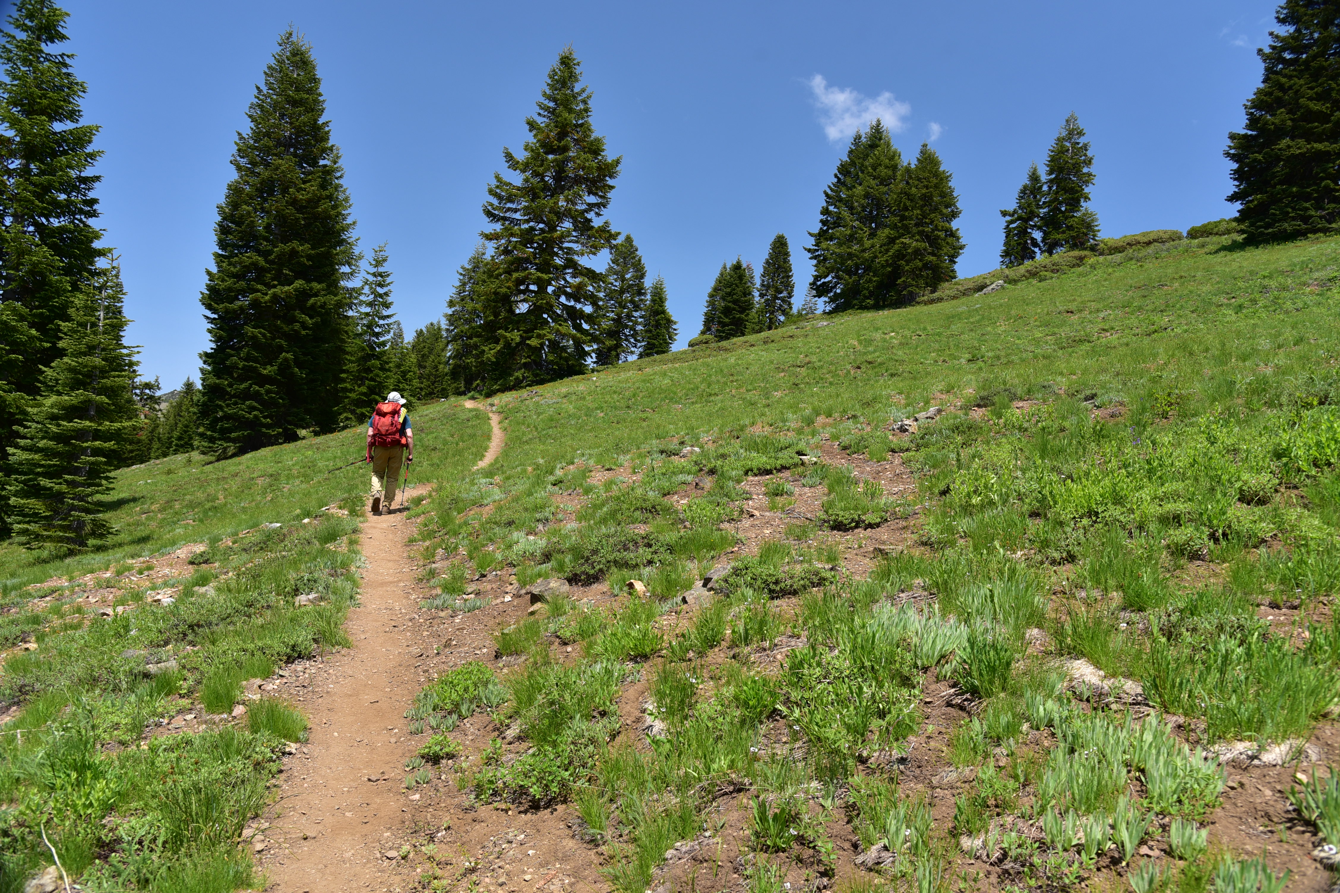
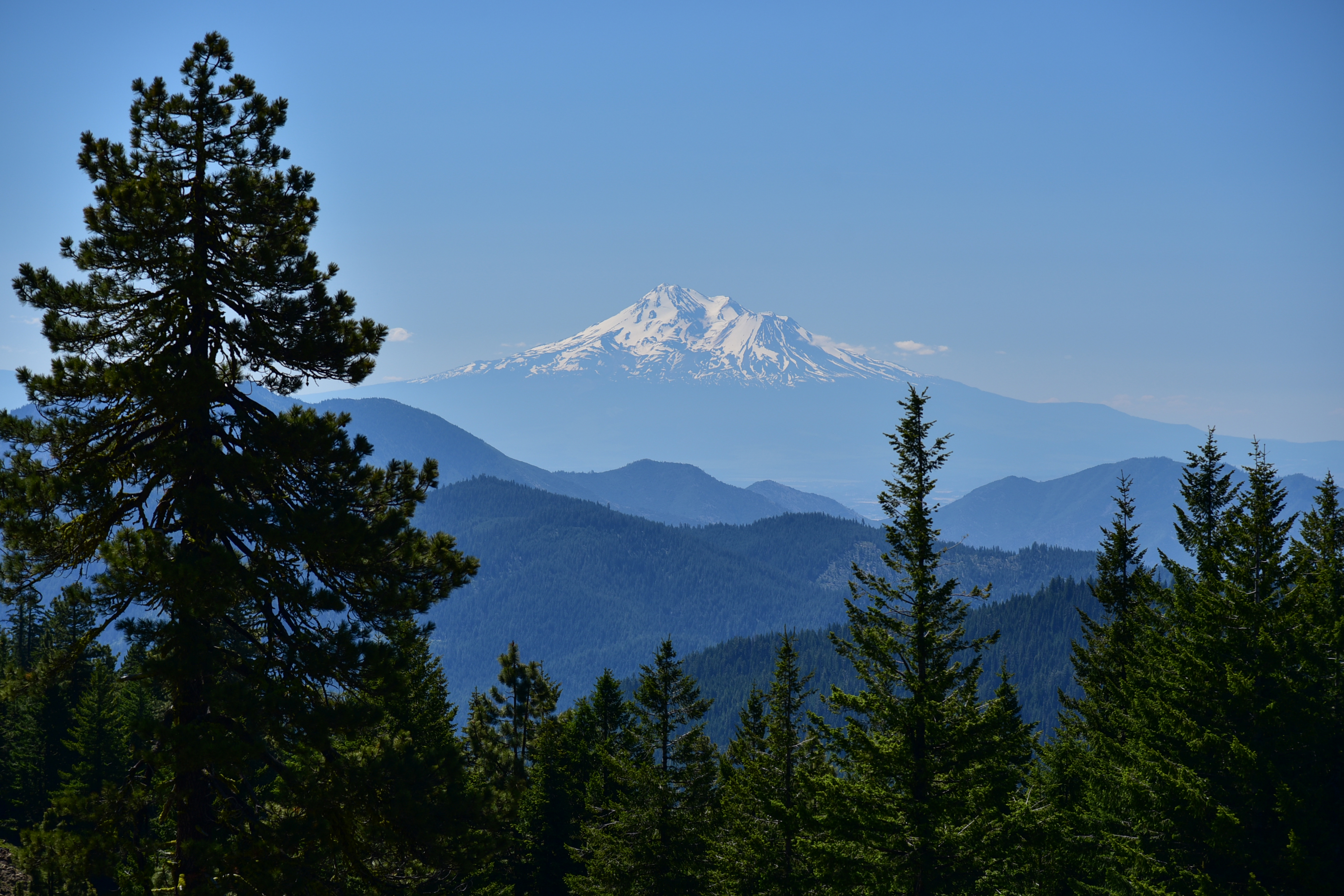
Sunday, June 23, 2019

After our hike up Bachelor Mountain, we headed over to Coffin Mountain for the short 1.5 mile hike to its summit. The flowers started off pretty much immediately:

Coffin Mountain Hike

Coffin Mountain Hike

Coffin Mountain Hike

Coffin Mountain Hike

Coffin Mountain Hike

When the trail entered the forest we started seeing lots of beargrass:

Coffin Mountain Hike

Coffin Mountain Hike

Coffin Mountain Hike

Out of the trees and still more beargrass:

Coffin Mountain Hike

Coffin Mountain Hike

Then we emerged into the huge summit meadow. This year it was full of beargrass:

Coffin Mountain Hike

Coffin Mountain Hike

Coffin Mountain Hike

Coffin Mountain Hike

Coffin Mountain Hike

Coffin Mountain Hike

Coffin Mountain Hike

Coffin Mountain Hike

We traversed the summit and switchbacked up it, then into the trees and out the other side to our first view of the fire lookout, which was not yet staffed:

Coffin Mountain Hike

We made it!

Coffin Mountain Hike

We sat on the deck and enjoyed the view of Mt. Jefferson:

Coffin Mountain Hike

Coffin Mountain Hike

And the Three Sisters:

Coffin Mountain Hike

Looking to the other end of Coffin Mountain where the radio tower is:

Coffin Mountain Hike

We enjoyed some afternoon wine and cheese:

Coffin Mountain Hike

Hiking back down through beargrass heaven:

Coffin Mountain Hike

Getting here meant a five-hour round-trip drive from Portland, which is not something we normally do for day hikes. But it was completely worth it to see the beargrass, which is one of my favorite wildflowers. Great day!

Bachelor Mountain

Sunday, June 23, 2019

We have been having cool cloudy weather in this last part of June, and unfortunately this weekend Saturday was the better day of the two. I was unavailable on Saturday, so today was my only day to head down and hike Bachelor and Coffin Mountains. It’s a five-hour round-trip drive from where we live, but Greg and I headed out Sunday morning.

On Road 1168 to the trailhead we passed a nice patch of beargrass alongside the road. This has been a great year for beargrass:

Wildflowers

Wildflowers

Wildflowers

Further along we passed another great flower patch, this time with rhododendrons and beargrass:

Wildflowers

There was also a big patch of monkey flower:

Wildflowers

I spent about ten minutes taking pictures, then I was ready to go. But Greg took 30 minutes to thoroughly document the entire area:

Wildflowers

We passed yet another roadside patch, this time full of delphinium:

Wildflowers

Wildflowers

Wildflowers

At the Bachelor Mountain trailhead we discovered that someone had inconsiderately built a fire ring right in the parking area. Seriously? I cleaned it up:

Bachelor Mountain Trailhead

Bachelor Mountain Hike

From the trailhead we could see the Coffin Mountain lookout perched high above us:

Coffin Mountain

Just five minutes up the trail we got our first sweeping view, including a view of the huge beargrass meadow on Coffin that we would visit later in the day:

Coffin Mountain

Mt. Washington, the Three Sisters, and the Husband:

Three Sisters

Three Fingered Jack:

Three Fingered Jack

There is a long open stretch on this trail with great views and wildflowers:

Bachelor Mountain Hike

Wildflowers

Bachelor Mountain Hike

Bachelor Mountain Hike

Bachelor Mountain Hike

Bachelor Mountain Hike

Coffin Mountain was visible behind us:

Bachelor Mountain Hike

The top of Mt. Jefferson was visible for awhile:

Bachelor Mountain Hike

We had a view of the Bachelor Mountain summit before re-entering the trees:

Bachelor Mountain Hike

We reached a junction with an old sign and a new sign:

Bachelor Mountain Hike

Bachelor Mountain Hike

We turned left for the last push to the summit. There were lots of about-to-bloom beargrass in the trees:

Bachelor Mountain Hike

Phlox:

Bachelor Mountain Hike

There was a patch of snow just below the summit:

Bachelor Mountain Hike

I reached the summit at 12:45. There were three people up there with their off-leash dog, who kept wandering around the summit while they kept shouting, “Dylan! Here Dylan!” The dog completely ignored them. Since your dog is not under voice control, how about trying a leash next time?

Mt. Jefferson now had a cloud in front of it:

Bachelor Mountain Hike

There was a good view of the area that burned in the 2017 Whitewater Fire:

Bachelor Mountain Hike

The views aren’t quite 360-degrees since there are trees, but you can still see a lot. Mt. Hood just barely visible through the clouds:

Bachelor Mountain Hike

Bachelor Mountain Hike

Looking northeast in the direction of Hood, not really visible in this shot:

Bachelor Mountain Hike

Looking north:

Bachelor Mountain Hike

And of course neighboring Coffin Mountain:

Bachelor Mountain Hike

The Three Sisters:

Bachelor Mountain Hike

Diamond Peak:

Bachelor Mountain Hike

Gold Butte Lookout:

Bachelor Mountain Hike

The fire lookout up here was burned down decades ago and there are just a few artifacts left:

Bachelor Mountain Hike

Bachelor Mountain Hike

Bachelor Mountain Hike

Hiking back down the clouds were getting thicker:

Bachelor Mountain Hike

Bachelor Mountain Hike

Now on to Coffin Mountain!