Sunday, October 30, 2021 Continue reading
Category: Badger Creek Wilderness
Lookout Mountain
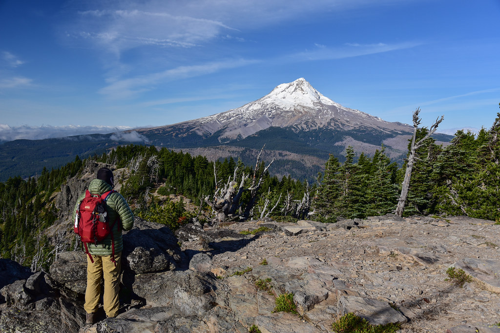
Saturday, October 17, 2020
Today we set out to hike up Lookout Mountain then take the Divide Trail over to Flag Point. Continue reading
Fall Larch Hike in the Badger Creek Wilderness
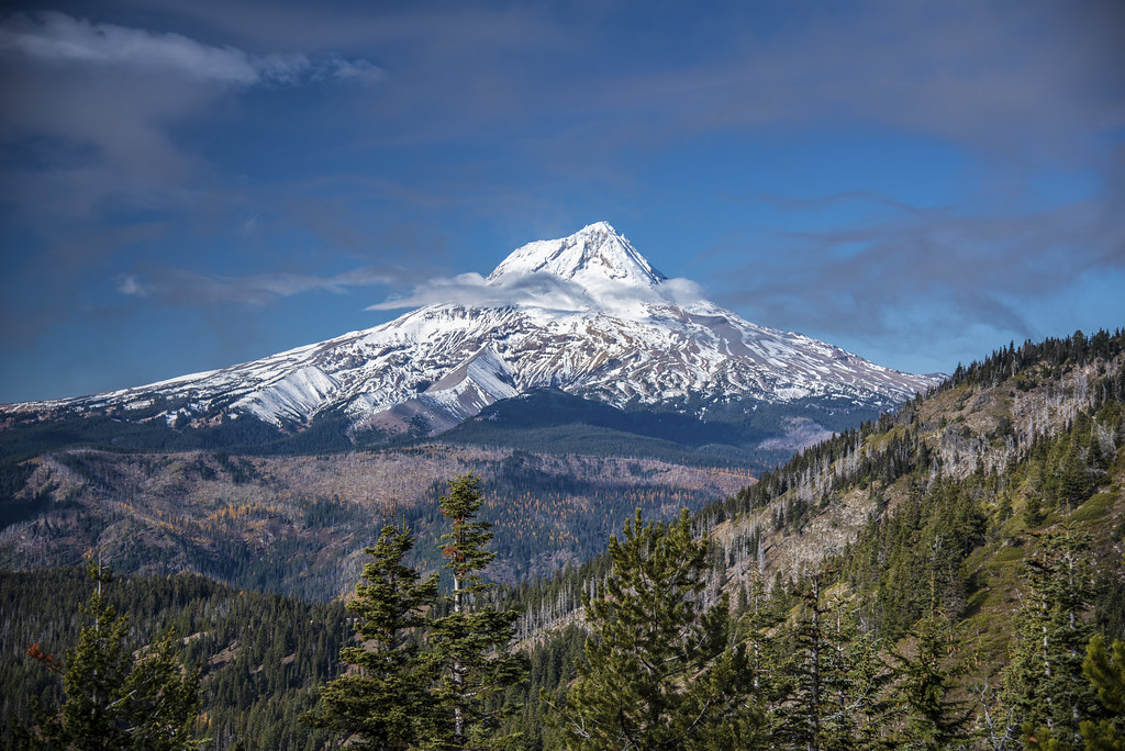
Sunday, October 21, 2018
In the fall larch trees turn a brilliant golden color and it’s quite a sight. Unfortunately larches aren’t common in the Oregon Cascades. There are some, however, on the east side of the Mt. Hood National Forest in and around the Badger Creek Wilderness. So on this gorgeous fall day Greg and I drove over there do a hike along the Fret Creek Trail and Divide Trail with Flag Point as our destination. It was a spectacular drive with beautiful fall color along the road including the larches we had come to see:
We parked on road 2730 near the Fifteenmile Campground and started up the Fret Creek Trail:
Many of the huckleberries had already dropped their leaves, but not all:
After a steep 2.1 mile climb we hit the Divide Trail and turned left heading east. We got a view of Lookout Mountain to the west (if we had turned right on the Divide Trail we would eventually end up there):
Soon we got our first view of Flag Point and its 41′ lookout tower:
We continued on the Divide Trail:
The larches against the blue sky looked beautiful:
The trail began descending:
After 3.7 miles the trail reached Road 200, the access road for the lookout, and turned right. Yes, you can drive this road, which we have done before, but it’s very rough. Much nicer to hike. We reached the gate that keeps people from driving all the way to the lookout and hiked past:
More beautiful larches:
At 12:45, after 4.4 miles, we reached the lookout:
The lookout was unstaffed which meant that the hatch to access the catwalk was locked. But we were able to sit on the stairs below the catwalk and enjoy the spectacular view of Mt. Hood with the golden larches peppered throughout the forest below us:
We could also see Mt. Rainier and Mt. Adams, although haze prevented a clear view of them:
And we could see east to the dry side of the mountains:
We had the place almost entirely to ourselves. A man and woman hiked up from some point down the road where they had parked. Some cyclists also stopped by and said that friends had come here yesterday and reported that the lookout was staffed and the guy fed them pancakes! It must have been his last day.
The temperature was perfect with just the right amount of warmth. The view was amazing. After spending nearly two hours sitting there soaking it all up we finally tore ourselves away at 2:30 and started heading back. After climbing up the Divide Trail regaining the elevation we had lost, we stopped and turned around for a last view of the lookout:
Our total for the day: 8.8 miles, 1700′ elevation gain. This is definitely now one of my all-time favorite autumn hikes. Even though there is some road-hiking involved and even though there is elevation to gain in both directions, the larches in their fall splendor is a sight to behold. Getting views from the lookout on a clear day is icing on the cake. Gorgeous!
Palisade Point
Our weekend plans went through several changes in just a matter of days. We had planned on going camping or backpacking with friends, but sadly they had to cancel for want of a dog-sitter. Then Greg and I decided to do a one-night backpack to Santiam Lake, until we got a look at the forecast and decided that was a bad idea. The forecast worsened, but I was desperate for nature time and staying home was not an option, so finally on Friday night we decided we’d go to the east side of Mt. Hood and hope that we’d at least stay dry, which we mostly did.
This forecast, by the way, is a real-life embodiment of that classic Oregon joke: What do you call two days of rain in Oregon? A weekend.
Let me translate what the weather guys are trying to say here: “We have NO idea what will happen.”
Yesterday we hiked the Fret Creek Trail up to Palisade Point. Almost immediately our progress slowed to a crawl due to the huge amounts of huckleberries all around us. There were SO MANY. YUM YUM.
Crossing Fret Creek:
It was very windy and the trees creaked and groaned around us. Sort of eerie. Just before reaching the Divide Trail we passed Oval Lake, which is more like a pond. We could see Palisade Point high above us.
Signage! You never know when or if you’ll see signs at trail junctions, especially in the Mt. Hood Forest.
Lots of this tiny sedum by the trail just before reaching the viewpoint.
We reached Palisade Point and got a good look at the sky above us. “Partly sunny.” Yeah. Right. We climbed up on the rock.
The views were very limited. Flag Point to the east:
The lookout was so tiny, even with the camera zoom!
That’s Lookout Mountain on the right, hiding in the clouds:
We climbed part of the way up that rock in the picture above. From there we could see down on Oval Lake.
Greg looking out over the Badger Creek Wilderness. The first rock we climbed is beyond, with Flag Point on the right.
It was CRAZY windy up on those rocks, and consequently quite cold. On a warmer clearer day we would have lingered a lot longer enjoying the views and sunshine. But on this chilly day we retreated into the protection of the trees and headed back down. We had considered adding Flag Point or Lookout Mountain onto our hike, but with the low clouds and lack of views we didn’t see the point.
On the way back down this little bird near the trail seemed to be posing for me. Held still while I got a few photos!
We were camped at little Fifteenmile Campground just down the road, so we dumped our packs, grabbed some sandwich bags, and went back for some more huckleberries. When we got home this evening we enjoyed them over Tillamook vanilla bean ice cream. DELICIOUS!
Lookout Mountain
Inspired by this report from Gunsight Butte last week, my goal on Sunday was to hike up Lookout Mountain and continue on the trail out to Gumjuwac Saddle and Gunsight Butte, then back the same way, which would have been about ten miles. Didn’t quite pan out though.
I got up at 6 a.m. so I could have good morning light on the east side of Mt. Hood. Google Maps instructed me to take Hwy 26 instead of I84 and Hwy 35 (I think Google Maps was wrong). I needed a pit stop and rather than stop at Government Camp, I decided to take a small detour to Trillium Lake and use their facilities after admiring the morning view at the dam. The view was indeed very lovely and it was nice and peaceful there. Just some fisherman along the shore and none of the loud hoards that I’m sure were there later in the day.
I continued on to the Lookout Mountain trailhead and hit the trail at 9:00. There were quite a few shooting stars blooming in High Prairie as I hiked through, but they were past their peak. But the meadows are snow-free and green!
Just after the meadows, about a quarter-mile from the trailhead, I hit the first patch of snow. It increased the further I went. But there were enough melted-out spots of bare ground combined with people’s tracks in the snow that I was able to find my way up the old road. The last bit to the summit was totally snow-free, as was the summit itself.
The views were, of course, insanely incredible. Broken Top, Three Sisters, Mt. Washington, and Mt. Jefferson:
The Badger Creek Wilderness, including Badger Lake and Gunsight Butte:
Dry central Oregon:
Flag Point, with the fire lookout just barely visible, poking up above the trees:
Mt. St. Helens:
Mt. Rainier and Mt. Adams:
The Hood River Valley:
And of course, front and center, Mt. Hood:
This is such a short and easy hike, with such an amazing reward. I felt like I hadn’t worked nearly hard enough to get to this amazing spot!
I spoke with a nice gentleman who was at the top when I arrived. He said he had done the hike to Oval Lake once (recommended as an add-on to the Lookout Mountain hike in Sullivan’s older guidebook editions) and that it wasn’t worth the effort. He said the trail to Flag Point was nice, though. But we both figured there was probably too much snow out that way. He left about 10 minutes after I got there, and I had the place to myself for the next 45 minutes. Just me and the mountains and the wildflowers.
Oh yeah, and bugs too. There were lots and lots of bugs. Fortunately only a few of them were mosquitoes and despite no long sleeves and no bug spray I only ended up with two bites.
I reluctantly left the summit to continue my hike over to Gunsight Butte. Although I think I found the right trail, it didn’t match up with the trail on the GPS and it seemed to peter out after about a quarter-mile. The day was getting warm, I was alone and not sure of my trail, so I decided to save it for another day.
I headed back to my car, slipping and falling hard in the mud while hiking through High Prairie. Ouch. I passed six other hikers on their way in (plus another hiker had arrived at the summit right before I left). And I saw a family getting ready at the trailhead and I passed four more cars on their way in as I was driving out. So I’m VERY glad that I got an early start and got to enjoy some solitude up there!
Since I was in the neighborhood, I decided to go check out Brooks Meadow, which I read about recently. Unfortunately, the watershed warning sign is pretty prominent (I was hoping it wouldn’t be and that I could claim to have not seen it). So I just took some shots from near the road and didn’t venture further, even though the fields of lovely wildflowers beckoned me. Oh well.
I needed some more exercise, so after Brooks Meadow I headed over to Barlow Pass. But that’s a different trip report, coming soon.