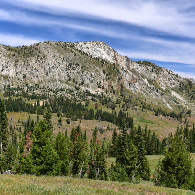
Ice Lake and the Matterhorn

Sunday, July 29 – Tuesday, July 31, 2018

Greg and I have been wanting to do the hike to Ice Lake for quite awhile and we finally made it happen this summer.

Ice Lake panorama

On Saturday the 28th we left Portland and headed east, arriving in Enterprise at 3:45pm and driving down Hurricane Creek Road to look for a campsite. All the dispersed sites were taken, so we just pitched our tent at the Hurricane Creek Trailhead. This trailhead is used by equestrians, so it was a bit stinky, but it was just for one night. The cooler temps sure were nice! It had been in the mid-80s in Enterprise but back in the canyon it was in the mid-70s.

Campsite

The trailhead parking was a little bit above the creek. We grabbed our chairs and headed down there to chill out. Very pleasant!

Hurricane Creek

Hurricane Creek

We could see Sacajewea Peak up the canyon:

Hurricane Creek

Sunday morning we broke camp and headed over to the Wallowa Lake Trailhead where we parked the car, put on our packs (mine was 33.5 pounds, Greg’s was 32.4), and hit the trail at 9:40am. The first few miles are along the West Fork Wallowa River:

Hiking to Ice Lake

Hiking to Ice Lake

Passing the wilderness boundary:

Ice Lake Trail

Occasionally we had a good view of the river:

Hiking to Ice Lake

But mostly we were just in the brush:

Ice Lake Trail

Stopping to admire the peaks above:

Ice Lake Trail

After hiking for 90 minutes and 2.9 miles we reached the junction with the Ice Lake Trail:

Ice Lake Trail

We crossed the river on this log bridge:

Ice Lake Trail

There used to be a much bigger bridge at this crossing but it was wiped out in 2011:


Photo by John Sparks

Downstream of the current bridge is a mess of logs and trees and I think maybe parts of the old bridge are in this mess:

Broken bridge

This video shows a crew putting in the new bridge in the fall of 2012. Wow, what an undertaking!

The trail switchbacks up through a grassy meadow:

Ice Lake Trail

Ice Lake Trail

Ice Lake Trail

We saw some burnt trees from the 2014 West Fork Fire:

Burnt trees

We were pleasantly surprised by all the wildflowers we saw, which lasted pretty much the whole way to Ice lake:

Ice Lake Trail

Ice Lake Trail<

Ice Lake Trail

Ice Lake Trail

Ice Lake Trail

Ice Lake Trail

At 12:20 we had hiked 4.5 miles and stopped for a break above a waterfall. According to the Northwest Waterfall Survey there are four waterfalls on Adam Creek: Lower Adam Creek Falls, Beauty Falls, Middle Adam Creek Falls, and Ice Falls. I believe this one is Lower Adam Creek Falls:

Ice Lake Trail

Then we continued climbing. Thank goodness for the numerous switchbacks and the well-graded trail, which made the elevation gain more bearable:

Ice Lake Trail

Ice Lake Trail

Ice Lake Trail

We passed another waterfall. I think this one is Beauty Falls (and off in the distance you can see another waterfall further upstream on Adam Creek, which may be Ice Falls):

Ice Lake Trail

Ice Lake Trail

Ice Lake Trail

At 5.7 miles we crossed a gurgling creek in a beautiful meadow. We stopped to rest and filter water:

Ice Lake Trail

Ice Lake Trail

Wildflowers

From the meadow we could see the slope up which the trail would soon be switchbacking:

Ice Lake Trail

And soon enough we were up there looking back down at the meadow:

Ice Lake Trail

The higher we got, the more impressive things looked:

Ice Lake Trail

Ice Lake Trail

Ice Lake Trail

Unfortunately the trail is showing signs of heavy abuse here. Every single switchback has at least one eroded shortcut:

Ice Lake Trail

Ice Lake Trail

I see the Wallowa-Whitman National Forest is still improperly using quotation marks on their fire ban signs, which we have seen elsewhere in this wilderness:

Ice Lake Trail

Air quotes

After nearly eight miles we’ve reached the lake!

Ice Lake Trail

The campsites are to the left, which requires crossing Adam Creek. There’s no bridge so I just plowed across and got my boots wet. I was too tired to care.

Ice Lake Trail

Greg tried this log:

Ice Lake Trail

The next day we would discover a big logjam at the lake outlet that is much easier to use for crossing:

Ice Lake outlet

Then we followed the lakeshore over to the campsites:

Ice Lake Trail

Since it was Sunday afternoon and the weekend crowd had cleared out, we had plenty to choose from. We found one we liked and called it good. We were too tired to explore around and find the “perfect” campsite. Besides, this one had a pretty good view.

Ice Lake Trail

Ice Lake Campsite

Ice Lake

We went down to the shore and enjoyed the cool water.

Ice Lake

This is a great swimming lake and Greg did just that.

Ice Lake

There were even some wildflowers (including heather!) blooming along the lake near our campsite:

Wildflowers

Wildflowers

Wildflowers

Wildflowers

We made dinner and enjoyed watching the lake:

Ice Lake

Ice Lake

We crawled into the tent before 8 to escape the mosquitoes. It never got very cold overnight, which was weird since we were at such a high elevation. Monday morning was gorgeous and as soon as I got out of the tent I grabbed my camera and started taking photos.

Ice Lake

Ice Lake

Ice Lake

We ate breakfast and hit the trail, heading off for the Matterhorn. From the east side of the lake we had a view of our destination, the white hump up there:

Ice Lake

Ice Lake

Matterhron

We crossed Adam Creek and turned left to follow the trail along the north shore of the lake.

Ice Lake

Ice Lake

Ice Lake

The wildflowers were beautiful!

Wildflowers

Hiking up the Matterhorn

Hiking up the Matterhorn

We left the lake and started climbing steeply:

Hiking up the Matterhorn

Hiking up the Matterhorn

Hiking up the Matterhorn

This hardy tree made a go of it for a long time, but didn’t make it. It’s still pretty, though:

Hiking up the Matterhorn

More wildflowers:

Hiking up the Matterhorn

Hiking up the Matterhorn

Hiking up the Matterhorn

Hiking up the Matterhorn

Hiking up the Matterhorn

We got high enough that we could look down on Ice Lake:

Hiking up the Matterhorn

By now we were well above treeline:

Hiking up the Matterhorn

Hiking up the Matterhorn

That’s the Matterhorn on the right:

Hiking up the Matterhorn

Looking back down at where we’ve been:

Hiking up the Matterhorn

There was a tarn way below the trail. We didn’t go down there because we didn’t want to have to climb back up to the trail:

Hiking up the Matterhorn

Almost there! You can see the trail as it enters the granite area of the mountain:

Hiking up the Matterhorn

Matterhorn

It’s hard to tell from this picture, but this side of the Matterhorn is actually riddled with user trails:

Hiking up the Matterhorn

And then we were at the top! At 9,826′ this is the second-tallest peak in the Wallowa Mountains. (Sacajewea is right next door and at 9,838′ it is the tallest. It is also Oregon’s tallest peak outside the Cascade Mountains.) We were disappointed to see that it was very hazy all around us. We had a signal on our phones so we learned that all this smoke was from hundreds of miles away, from southern Oregon and even Redding, California. All of Oregon was covered in smoke. Yuck. I cleaned up this shot in Photoshop, but the rest are straight out of the camera:

View from the Matterhorn

Looking northwest. That’s Hurricane Creek way down there:

View from the Matterhorn

View from the Matterhorn

Looking across to Granite lake:

View from the Matterhorn

And Billy Jones Lake:

View from the Matterhorn

Looking north. You can just barely make out the farmland of the Wallowa Valley out there, but it’s so hazy it’s hard to see:

View from the Matterhorn

Looking south. The peak on the right is Eagle Cap, which we hiked up in 2013:

View from the Matterhorn

Here is the view from Eagle Cap looking north to the Matterhorn on that rainy 2013 visit:

Looking north

Panorama:

Matterhorn View

There are two summits on the Matterhorn and we weren’t sure we were on the true summit. It looked like the other one might be taller, so we headed over there:

View from the Matterhorn

View from the Matterhorn

But once we were up there and looked back, we thought maybe the other one was the true summit. In any case, we never found a survey disk or a summit register on either summit.

More view shots:

Matterhorn View

Matterhorn View

Matterhorn View

After sitting and enjoying the view for awhile and having a snack, we headed back down. The whole time we were up there we only saw one other hiker.

Matterhorn View

Matterhorn View

On the way back down the views of Ice Lake were better since the sun was now behind us:

Matterhorn View

Ice Lake

Ice Lake

More wildflower shots:

Wildflowers

Wildflowers

And then finally we were back down to lake level. This scene was just too lovely!

Ice Lake

Hiking back along the north shore of the lake:

Ice Lake

Ice Lake

Ice Lake

Untitled

Wildflowers

Crossing the lake outlet:

Untitled

After a little more than four miles round-trip (it sure felt longer than that!) we were back at our campsite. Greg went swimming again and I waded. It felt good to relax and cool off after our steep hike:

Time for dinner! We drank the rest of the wine we’d packed in, which we “chilled” in the lake. (It didn’t actually get very cold.)

Time for dinner

Chilling our wine

That evening I wandered around about a bit to see what there was to see. Our campsite was on the peninsula you can see in the photos I took from above, so there was a cove back there that provided some lovely photo ops:

Ice Lake

Ice Lake

Campfires are not allowed at Ice Lake at any time, yet I saw evidence of them anyway. I spent ten minutes dismantling this fire ring. I forgot to take a “before” shot, but here’s the after:

Illegal campfire

It was another not-cold night, and when we woke up Tuesday morning we found that after 24 hours of smoke drifting into the area we now had super hazy skies. Some clouds had rolled in too.

Ice Lake

Ice Lake

We enjoyed a quiet breakfast with just the sounds of a few birds and the lake water. Very peaceful.

Backpacking breakfast!

We packed up, said goodbye to Ice Lake, and started heading down:

Ice Lake

These rocks weren’t fun going up and they weren’t any more fun coming down.

Ice Lake Trail

Hazy skies and clouds made for humid hiking:

Smokey skies

We paused under the log bridge for a break before the final push back to the car:

West Fork Wallowa River

We had a room (and hot shower!) waiting for us at the Indian Lodge Motel in Joseph:

Post-hike hotel

After a most-refreshing shower we drove over to Enterprise and had dinner at Terminal Gravity:

Terminal Gravity

Great trip! It was fantastic to finally visit this gem and it was REALLY awesome to not be there on a weekend so we could enjoy some peace and quiet. Ice Lake is truly even more gorgeous than I had imagined, and it was cool to hike up the Matterhorn even though we had to deal with some smoke. In total we hiked 20 miles!

Happy backpackers

Little Eagle Meadows

After our three-day trip with the Wallowa Llamas, Greg and I had one free day before driving back to Portland. So we went on a day hike up to Little Eagle Meadows, starting at the Summit Point trailhead. This hike to the meadows was the first part of the longer hike up to Pine Lakes, which is the hike we were supposed to have done with the llamas. But there was too much snow higher up, so our llama guide took us to Eagle Meadows instead.

My sister and I did this hike last year in late June and it was too early for the massive lupine displays. All we saw were thousands of lupine leaves. Fortunately, Greg and I saw plenty of blooming lupine. Here he is coming up the trail behind me, surrounded by the purple wildflowers.

The trail climbs up and up and up. It was fairly brutal in parts. I was very tired. Fortunately, it wasn’t hot. In fact, we got drizzled on a little bit. It’s amazing how fast the weather changes. At the trailhead it was hot and sunny and I left my rain jacket in the car. Half an hour later the sun was gone and it was drizzling.

Finally we reached the massive meadows. It really should be called Big Eagle Meadows, not Little Eagle Meadows. Cornucopia Mountain makes a nice backdrop.

The lupine was EVERYWHERE and it was gorgeous. And for every blooming lupine we saw, there were even more that hadn’t bloomed yet. I’ve never so many lupine in one place before.

There were other wildflowers blooming up there too.

We had a nice view of the mountains and the distant rain on the hike out.

Beautiful hike! Probably about five miles round-trip to the meadows and back, with about 800 feet elevation gain.

Trekking with the Wallowa Llamas in the Eagle Cap Wilderness

When Greg won the 2006 Oregon Wild photo contest, one of his prizes was a gift certificate for a three-day, two-night trip with the Wallowa Llamas. So we redeemed that gift certificate on July 18 and went on an awesome trip into the beautiful Eagle Cap Wilderness. The whole set of pictures is here.

We started out on Friday at the llama ranch just north of Halfway. Seven llamas got loaded into the back of an old school bus (bwahahahaha!). We humans rode up front.

We were supposed to start at the Summit Point trailhead and hike up to either Pine Lakes or Crater Lake. But the trail went into higher mountain territory where there was still snow, so we started at the Boulder Park trailhead and hiked into Eagle Meadows instead, which turned out to be a blessing in disguise since I’m still not in the best of shape after being laid up with a broken foot all of May and June.

After the hour and 45 minute drive up and down Forest Service roads, we arrived at the trailhead. The llamas were unloaded, saddled up, and laden with heavy packs. (We humans just carried day packs…woo hoo!)

Besides me and Greg, there were four other guests in our group, in addition to our tour guide, Raz, and his assistant Lisa. Raz and Lisa brought up the (distant) lead with the llamas while the rest of us hiked on ahead to our lunch spot. The scenery was instantly spectacular. This is the meadow we crossed just before reaching our lunch spot 2.5 miles from the trailhead.

We ate a delicious lunch (all the food was provided on this trip) by Eagle Creek. Raz has these two wooden cook boxes that when put on the ground side by side served as a nice flat preparation area, with the utensils and supplies inside within easy reach. Our feast of a lunch consisted of bagels, bread, salami, cheese, homemade red pepper spread, fresh veggies, and delicious cherries from their orchard!

After lunch, we had to cross Copper Creek, which had no bridge. I chose to wade rather than risk falling off one of the logs spanning the creek. The creek was wide, but only ankle deep. Shortly after crossing the creek, we could see Copper Creek Falls crashing down a cliff.

Greg bushwhacked over there when we hiked out on Sunday and although it was too sunny for a photograph, he got a video of the falls. Pretty impressive.

This is Bench Canyon Falls, which splashed down right by the trail.

In the late afternoon, after hiking 4.4 miles from the trailhead (and gaining about 1,300′) we arrived at beautiful Eagle Meadows. It stretches a lot further than this picture conveys. Eagle Creek runs through it. What an idyllic setting!

After Raz, Lisa, and the llamas arrived, some of us helped Raz lead the individual llamas to grazing ground. You take their lead rope and they follow you around without question. They’re quite curious. They grazed a little distance from camp and whenever we were out peeing or collecting firewood or taking pictures, they would watch us intently.

We set up tents while Raz and Lisa started on dinner. In addition to a stove, they had an oven setup which was pretty nifty, allowing Raz to heat up the meals that his wife had cooked and frozen for us a few days before. We had fresh veggies with ranch and blue cheese dip, merlot and chardonnay, raging bull chicken over quinoa, homemade Scottish oat bread, plus banana bread for dessert and a post-dinner drink of tea or hot chocolate.

We were all feeling pretty tired, so by the time dinner was done and cleaned up, we were ready to turn in. The days are long this time of year, so it was still a little light out when we went to bed. I slept better than I did when I went backpacking last summer. I stayed warm, for one thing, despite the fact that we woke up to frost in the morning. I woke up in the middle of the night and stuck my head out of the tent to see the stars, but it was just past the full moon, which made the sky too bright to see all the stars I might have. Still, there were a lot, and the bright moon illuminated the mountains and meadow all around us. It was VERY cool!

Morning dawned bright and beautiful and despite the overnight frost it warmed up very quickly as the sun came over the mountains.

After a breakfast of fresh cantaloupe plus Swedish pancakes and coffee and tea, Greg and I wandered the meadow taking pictures while Raz and Lisa moved the llamas to fresh grass. The scenery was stunning and vast. I wished I’d had a wide-angle lens! Next time. This is stitched from two shots.

We all set off on a day hike up to Eagle Lake, the source of Eagle Creek. It was 2.9 miles away and 1,300 feet above us. The scenery along the way was fantastic. Here is the group hiking toward Needle Point.

We saw lots of different wildflowers, including more penstemon than I’ve ever seen in my life.

We stopped about halfway up and Raz made us lunch, which included fresh veggies, gouda cheese, brie cheese, crackers, slices of baguette, and kippered herring. For dessert we had homemade ginger cookies plus apple slices with gjetost, a Norwegian goat cheese that made a pretty good pairing with the apples. One of the best trail lunches I’ve ever had!

Being out of shape and picking my way carefully up the rocky trail, I found the going tougher than I normally would. It was also pretty hot, well into the 80s, and the stunted trees provided little or no shade. But the scenery kept me motivated.

Beautiful Eagle Lake was a welcome sight. At 7,500 feet, it still had large patches of snow on and around it. Not surprising, considering the winter we had this year. The water was VERY cold! I was hot and could have used a refreshing toe-dip, but I refrained. Lisa, however, dove into the icy water not once but twice! Brrrrrr!

There was heather growing along one side of the lake. I sat on the shoreline surrounded by it and admired the lovely view. Damn, the Wallowas are gorgeous!

The hike back down was just as hard as going up because of the rocky trail. I was paranoid about my foot and where I put it, so it took a lot of concentration to watch where and how I walked. I stumbled a few times, but made it back down okay. Back at the meadow, Greg and I washed up at the creek while dinner was being prepared. Ah….so refreshing. The creek ran along the edge of the meadow near our tent and made for pleasant background noise while we slept at night.

My hunger overcame my general dislike for lasagna and I ate some at dinner that night. That was after having eaten quite a few crackers with sundried tomato pesto and cream cheese. As if that weren’t enough, we had salad with pomegranate vinaigrette (YUMMY!) and garlic bread, plus apricot bread for dessert. I will never eat this good in the backcountry again!

During dinner we saw a deer in our camp nearby. She seemed wary, but definitely not frightened of us. We would see her again periodically throughout the evening and next morning. She passed within 20 feet of me when I was back in the trees peeing. I spoke softly to her so as not to startle her. She looked at me and decided she didn’t like being that close and walked (not ran) away.

No frost Sunday morning, but it did sprinkle a few times in the early morning. But it didn’t last and once the sun was up it warmed up even faster than it had the morning before. After a breakfast of Mexican grits, muffins, and oranges, we packed up and headed out.

Whereas the llamas had been half an hour behind us on the hike in, they were about 15 minutes behind us on the first leg out. So after crossing Copper Creek, waiting for Greg to come back from his waterfall expedition, I was able to get a shot of the llamas in action, fording the creek. They are very sure-footed, not giving a second (or even a first!) glace to where they’re setting their feet.

Back at the trailhead, the llamas were loaded in the bus and we set off back towards Halfway, where I had a delicious shower that night at the hotel. Oh those post-backcountry showers are so wonderful.

All in all, we had a wonderful time! Our group wasn’t too big (they can be as big as ten guests) and they were fun people to talk with. Raz and Lisa were awesome leaders and cooks and they handled pretty much everything having to do with the llamas. They seem to be gentle patient creatures. The only troublemaker was three-year-old McNash. It was his first time doing this and he gave poor Lisa a hard time. He wouldn’t walk with the other string of llamas and Lisa had to lead him by himself. Even then he gave her some trouble. Here he is getting saddled up at the beginning:

We didn’t see many other people. Over the course of our three days, we saw a few people with horses, a few hikers, and a few backpackers, probably a dozen people total the whole weekend. The scenery was stunning, the food was awesome, and the llamas carried all our stuff! This is the way to go! I was enchanted with the Wallowas after my visit last year, and I remain enchanted. Greg and I both want to go back again. And again. There are a lot of trails to hike, lakes to see, and mountains to gaze at.

Lakes Basin – Eagle Cap Wilderness

else who decides to visit this area so early in the summer like we did, I thought I’d go ahead and post a report.

The Eagle Cap Wilderness in the Wallowa Mountains is one of the most gorgeous places I have ever had the privilege to visit. And the Lakes Basin area in that wilderness is divine. My sister and I had eight days in NE Oregon, and we planned on three nights in the backcountry. Although we tossed around different ideas, we knew we couldn’t pass up the scenic lakes. We figured that since we were there so early in the year and it was the middle of the week, we wouldn’t run into the legendary crowds that descend on this area in the summer. They told us at the ranger station that we would likely run into snow, but we went for it anyway.

Day 1

We started from the trailhead at Wallowa Lake. The first six miles of the trail climbs slowly and steadily upwards, paralleling the West Fork Wallowa River, while huge mountains tower above you on all sides.

Majestic mountains

After six miles, we reached – wait for it – Sixmile Meadow. We stretched out on a sunny rock and soaked up the sunshine and the views. It was a gorgeous perfect day. A ground squirrel kept us company out in the meadow, watching us curiously for awhile, scampering around, watching us some more, but never approaching. I would hope that the type of people who make it in this far know better than to feed the wildlife. We did see one other person here, our first -and only – person-sighting of the day back here. He got out his fishing pole and headed down to the river, which borders one side of the meadow.

Sixmile Meadow

From Sixmile Meadow, the trail continues straight up to Frazier Lake. That would be our return route. We hopped onto the Lakes Basin Trail that would take us a further 3.1 miles up to Horseshoe Lake, where we would camp for the night. This trail immediately has two water crossings, neither of which have bridges anymore, though they once did. We crossed the Wallowa on a long but sturdy log. This is the first time I’ve had to cross such a wide river on a log, and definitely the first time I’ve had to do it with a heavy pack. I got a bad case of nerves in the middle of the log, shaking legs and everything. But I made it!

Log crossing

The next crossing, less than a minute later, is across Lake Creek, where the washed-out bridge is still visible. (Talking to the people at the ranger station afterwards, we learned that
these bridges have been out for several years, but that there simply
isn’t staff or money to replace them.)

Bye bye bridge

As you can see from the picture, there are PLENTY of logs down across the creek to choose from. And the creek is shallow enough to wade too. We chose a log. And once again I made it across without falling in!

And then began what felt like a really difficult climb up to the lake. It’s an 1,100 feet gain in those 3.1 miles, which really isn’t bad. But it was the end of the day and my pack was feeling really heavy (and, I’ll admit it, I was not in the best of shape). But man, once we arrived at Horseshoe Lake, all that work was SO worth it. We circled around to the west side of the lake where the campsites were. The huge areas of bare ground amongst the trees there was all the evidence we needed that this area is VERY popular. On a Monday evening in June, though, we had the place completely to ourselves. As we set up camp and made dinner, I kept running out of camp to the edge of the lake to see the view. And what a view it was.

Evening at Horseshoe Lake

It got very cold very fast. The low temps combined with the nearly full moon and the long wait for total darkness meant that we didn’t see stars that night. Even with the nearly full moon we still would have seen a ton, but we were too tired and cold to wait up for them. Darkness is a long time coming during these longest days of the year!

Day 2

Tuesday was another gorgeous day with clear blue skies. We hiked on from Horseshoe Lake, passing Lee Lake and Douglas Lake. Somewhere on the trail between Douglas and Moccasin Lakes, we encountered our first snow, at about 7,400 feet.

First encounter with snow

But despite this little bit of the snow, the trail was pretty clear sailing up to Moccasin Lake. We ate lunch on a rock ledge overlooking the lake, with a clear view of Eagle Cap straight ahead. Our original plan had been to camp somewhere in this vicinity on this day and climb Eagle Cap, then go camp at Glacier Lake on our third night. HA! We took one look at all the snow up on Eagle Cap and decided it would be a bad idea to go up there. While eating lunch here, we did see some hikers coming down from there, cutting cross country and sliding down the snow on the mountainside, rather than taking the trail. We actually ran into them the next day and they said the trail up there was pretty well covered in snow for the first part, but that the last part was actually not too bad.

Lunch with a view

We took a short side trip up to Mirror Lake before continuing on up to Glacier Pass. Mirror Lake is yet another gorgeous alpine lake backdropped by majestic mountains, which were still pretty well covered in snow when we were there, an indication of what we soon faced. We saw a few campers there, as well as a few down at Moccasin Lake. Back down at Moccasin Lake, we crossed the inflow stream on rocks and trekked off toward Glacier Pass. [Begin ominous music here!]

Goodbye, Moccasin Lake

The first little bit after the lake was fine. It got a bit soggy in places, but it wasn’t too bad. But soon enough we started encountering more and more snow on the ground. We quickly lost the trail, and knowing we had to cross the creek at some point, we crossed at a spot that looked like where the trail would go. Because the creek was raging with snowmelt, we had to take our boots off and wade. And it turned out that unfortunately, this was not the place where we needed to cross, which we discovered after bushwhacking around for an hour and not finding any trail. So we waded back across and managed to discover where the trail continued upstream, buried in snow.

And so began a brutal and grueling climb. The trail switchbacks a lot here, but since it was all buried under snow, we just went straight up. The melting snow was wet and slippery, and keeping our footing was extremely difficult. Deborah broke trail, bless her. We finally reached the real creek crossing, mostly buried under snow. We filtered some water and pushed on.

Awful snow

We had to climb again, coming out of this creek valley and up to Glacier Pass. More snow to cross. Lots more. My morale plummeted with each slow step. FINALLY, we were on the last push to the pass, and ironically that section was free from snow, even though it was of course higher than all the trail we had just traversed. After 2.7 miles, 4 hours (which included our lost hour when we crossed the creek too soon) and 1,000 feet of elevation gain, we reached Glacier Pass at 6:30 p.m. Oh joy! But then we looked down on the other side of the pass at Glacier Lake and my suspicions were confirmed:

Frozen

The lake had only barely begun to thaw out and was still mostly covered in ice. The land around the lake was still buried in snow. The outflow from the lake was also under snow. We could hear it raging under there, but we couldn’t see it until it emerged from the snow a short ways down. We would not be camping here tonight. I was pretty bummed out. Not only was I exhausted from our snowy climb to the pass, but I had heard how scenic Glacier Lake was, the most photographed lake in the wilderness. We learned from the ranger station later that this lake is one of the last to thaw out in summer.

So we pushed on to Frazier Lake, down the valley two miles. We could see the trail clinging to the valley wall further down, but to get there we first had to make our way down a steep snowy slope. According to the map, the trail wrapped around down along the lake, but we just made our way straight down, completely bypassing the frozen lake. Eventually we broke free of the snow and hit dry trail. As we lost elevation, we started to see a few wildflowers here and there. During the course of the two hours it took to travel the two miles from Glacier Pass to Frazier Lake, we went from winter to summer, just like that. At Frazier Lake, we pitched the tent and made dinner quickly, then fell into bed exhausted.

Day 3

Wednesday morning we woke to more blue skies and warm sunshine. The snowy mountains seemed to rise right out of Frazier Lake.

Morning reflections

The morning was beautiful, but the mosquitoes were out. It was the first time we encountered significant mosquitoes on this trip. We later read that this lake is particularly notorious for the little bastards. So we ate breakfast, broke camp, and headed out.

The trail follows the West Fork Wallowa River down to Sixmile Meadow, where we had headed off to the Lakes Basin two days before. We could see down the length of the valley, at the end of which lay our car and Wallowa Lake.

Long valley

You have to ford the river at some point, which was slightly scary. It was raging with freezing cold snowmelt. I’m pretty short (5’3″), so the swift water soaked me to my upper thighs. I imagine that later in the summer it’s not so bad, though.

After the river crossing, the trail just continues its slow descent out of the long valley. It’s 10.1 miles from Frazier Lake to the trailhead. We saw quite a few wildflowers along this stretch of trail, which was fun. The lens on my camera started acting up, and my tiredness increased with each step, so my picture-taking rapidly decreased. The last mile of the trail, I was really dragging. I was really happy to see our car waiting for us at the trailhead! We splurged that night and paid to camp at the state park (hot showers!). We had beer and pizza in Joseph and slept like logs that night.

This was a GREAT trip. Deborah’s pretty experienced, but It was my first “real” backpacking trip. I’m not a fan of walking around with 35 pounds on my back, but being able to experience parts of the backcountry that you can’t see by day hiking was SO worth it. I’m hooked! Now I just need to get in better shape.

If you do this trip in late June, be prepared for snow. We actually got lucky. The snowpack was pretty low this year; otherwise we would have encountered more snow and at a lower elevation. While the snow is a disadvantage for a late June trip, we were early enough that we beat the worst of the mosquitoes. Even the ones at Frazier Lake weren’t as bad as some I’ve encountered. And we beat the crowds (it also helped being there during the week). This area is really beautiful, and I already can’t wait to go back and explore more of the wilderness.