Friday, September 4 – Monday, September 7, 2020
For our four-day Labor Day weekend we headed to the Three Sisters Wilderness. Continue reading
Friday, September 4 – Monday, September 7, 2020
For our four-day Labor Day weekend we headed to the Three Sisters Wilderness. Continue reading
Saturday, August 8 – Sunday, August 9, 2020
Greg and I don’t get down to the Three Sisters Wilderness very much. The northern part is closest and is also busy and crowded and burned (the area has been plagued by huge wildfires in recent years). But this weekend we decided to make the long drive from Portland to do a one-nighter at Camp Lake. Continue reading
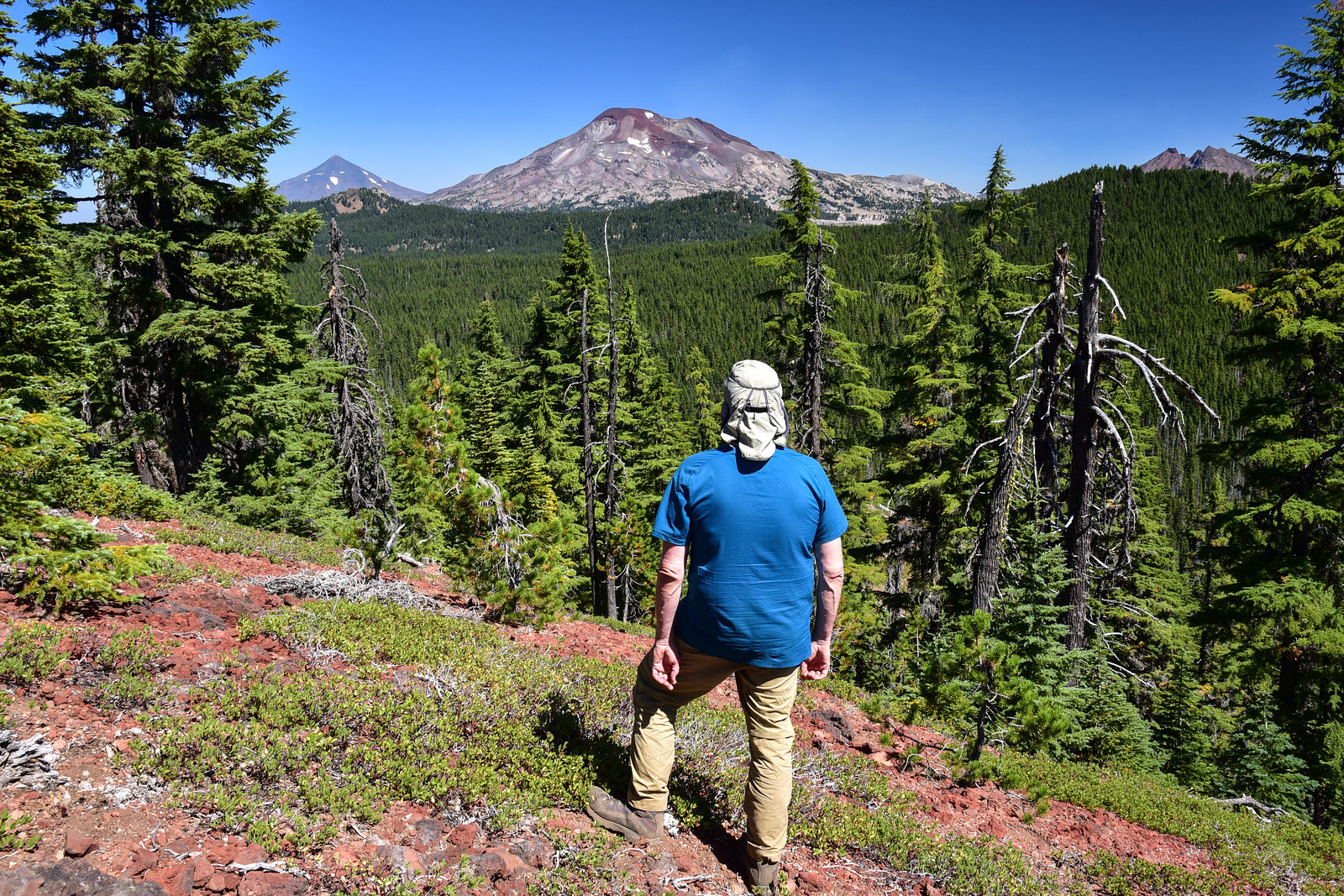
Monday, September 2, 2019
After our stay at the nearby Indian Ridge Lookout we decided to do the hike up to Lowder Mountain before driving home. Continue reading
UPDATE: On August 4 the Rebel Fire started in this area and ended up burning over 8,000 acres, including the majority of this hike. The lookout did not survive the flames. Here is a photo of the area where the lookout once stood.
I’ve wanted to do the Rebel Rock Loop for awhile, so when I saw on the Willamette National Forest’s Facebook page that a crew had logged out the entire loop, I figured now was the time to go, before another winter arrived and brought down more trail-blocking trees. It’s a long one, a good 12.5 to 13 miles (depending on who you ask). But there is old growth, wildflowers, views, and almost no people! We did not encounter snow, but we had plenty of mosquitoes for company.
We hit the trail at 9am. The trails split very near the trailhead and this was the last directional signage we saw on the hike:
We did the loop clockwise, hiking up the Rebel Creek Trail. It crosses the creek twice in the first mile.
A cool old mile marker:
The shady forest was pleasantly cool on this warm day:
A wilderness sign that’s seen better days:
The climb was gradual and the forest pleasant, with some nice old growth:
We did see signs of the recent trail work. Thanks, crew!
Took a break at this lovely gurgling creek:
Although I didn’t do a track on this part of the trail (wish I had), I was watching our progress on the map via the Gaia GPS app. According to the GPS we had already passed the junction, but we had been looking for it and not seen it. We got to this very overgrown meadow with an old signpost and we could just barely make out the trail we wanted. If not for that old post, we probably would have walked right past the junction. I definitely appreciate the log-cutting by the trail crew but I wish they’d had time to brush out the trail as well.
The trail traverses the slopes below Rebel Rock, which was hidden above us on the left. This part was all overgrown as well:
Looking across the canyon of that little side creek we crossed earlier:
There were bees and butterflies all over the place:
We crossed some open rocky clearings with wildflowers, including scarlet gilia:
We got our first glimpse of the lookout:
Further down the trail, an unmarked side trail leads to the lookout. There was a cairn when we were there:
The lookout was built in 1955, but it hasn’t been staffed in about 50 years. It’s in bad shape, but considering how long it’s sat here abandoned, exposed to the weather, it’s amazing that it’s still standing at all.
The old outhouse in the woods is still standing:
The lookout is unusual in that it’s not on a summit with a 360-degree view, but perched on a cliff with a view in only three directions. It looks south out over the South Fork Mackenzie River.
The only Cascade peak you can see is Mt. Bachelor, although of course back when this was an active lookout that peak was known as Bachelor Butte:
Chucksney Mountain:
Back on the trail we continued on through more rocky clearings with wildflowers:
One of these clearings has a view back into the heart of the wilderness with views of Mt. Jefferson and the Three Sisters:
We kept looking back from this stretch of trail to get a glimpse of Rebel Rock, but we never did see it. Maybe we just didn’t turn around at the right spot. The trail switchbacks down through sloping meadows:
And there were more meadows like the ones we had hiked through earlier, with head-high vegetation that obscured the ground at our feet, including any obstacles. We’d come across several holes and always managed to avoid them, but then Greg stepped in one and went down. He wasn’t badly injured, but his foot was now hurting and we were still four miles from the trailhead. Yikes.
Greg soldiered on and it was a relief to leave the overgrown meadows behind and re-enter the forest:
Another old mile marker. Three more miles to go:
We saw a surprising amount of old phone line from the days when the lookout was active. It was hanging from insulators in the trees along the trail:
Hiked across the wilderness boundary:
Then just a short distance from the trailhead, well past the wilderness boundary, was this new-looking sign. Interesting;
We finally got back to the car at 5:30. I knew this was going to be a workout hike and it was. My feet were hurtin’ by the time we were done. We cooled our aching feet and legs in the creek near the trailhead.
Here’s a video of the hike:
I spent this past weekend camped at French Pete Campground and exploring the area with some day hikes. On Friday I headed for the Three Sisters Wilderness to hike the eight mile loop that goes past Erma Bell Lakes and Williams Lake.
On the way to the trailhead I saw a doe and two fawns on the road ahead. That’s the second time in less than a week!
The fawn on the right didn’t know what to do. Rather than follow mom, it ran to the right and hid in the bushes right by the side of the road. I snapped a quick picture through the window then moved on so the poor little guy could reunite with his family.
The trail is FLAT. It’s also shady. Both of these qualities were perfect for another scorching hot day.
A young grouse exploded out of the brush and flew up into a tree, scaring the crap out of me. A few seconds later a sibling did the same and headed for a different tree. And then a much bigger grouse, surely the mother, followed suit, and made annoyed noises at me from her tree. Here’s a picture of the first grouse.
The lower of the three lakes. Sheesh, it was hot in the sun after being in the forest!
In-between the lower and middle lakes is a lovely waterfall, which the Northwest Waterfall Survey calls Erma Bell Lake Falls. It’s right off the trail and the partial viewpoint from the top is easy enough to get to, although to get to the bottom requires a bit of scrambling on a steep booth path.
If you look at the topo map, it looks like there are a number of waterfalls on this creek downstream of the lower lake. The creek takes a dive off the plateau on its way to the Middle Fork Willamette River. Steep terrain there.
The middle lake. Man that water is CLEAR!
There were quite a few iridescent blue dragonflies at this lake.
The upper lake:
I get the sense that all three of these lakes are very popular backpacking destinations. There were signs everywhere about camping in designated campsites only. Unfortunately the Forest Service doesn’t provide any maps or guidance about finding these designated campsites. They don’t even tell you how many there are at each lake.
At last, Williams Lake! This is where I allowed myself a nice cool dip, although frankly the water was shockingly warm. There was none of that adrenaline rush you get dipping into a cold body of water, because it was not cold at all. Still felt refreshing though!
Spotted a toad:
After lingering at the lake for awhile, snacking and soaking, I continued on to finish the last part of the loop. After a long dry stretch through the woods, Otter Lake was the last lake on the loop:
Considering it was a holiday weekend and considering the presence of so much swimming potential, I was surprised to see no other hikers on the trail. The only people I saw were some dads and sons who had already set up camp at the lower lake when I hiked by. There’s nothing spectacular and jaw-dropping about this hike, but it’s lovely all the same.
Once again, our plans to head to Jefferson Park were thwarted. Despite a string of cold wet weather, the wildfire north of Mt. Jefferson had a closure in effect that would have kept us out of the Park Ridge area. So we headed to the Three Sisters area instead. We chose the 23-mile Broken Top loop as described in Doug Loraine’s 100 Classic Hikes in Oregon.
We drove out to Three Creek Lake after work on Friday and set up camp in the dark. The sky was clear and we could see a million stars. If not for the cold (it was about 37 degrees out, according to the thermometer in my car), I could have sat out there for awhile admiring them. They were very very cool.
In the morning we set off on the loop. Loraine recommends going counter-clockwise, but because we wanted good morning light for photography on Tam McArthur Rim – which would have been at the very end of the loop on the second day if we did it counter-clockwise – we decided to go in reverse.
The last time we hiked up Tam McArthur Rim, the weather was wretched. There were no views and it actually snowed on us a bit. This time the sky was clear as a bell and we had fantastic views.
Tam McArthur Rim and Three Creek Lake
The views get better and better! Middle and North Sister, as well as Mt. Washington and Three Fingered Jack
That really discouraging and steep sandy hill you have to climb. This picture does not do it justice.
From Tam McArthur Rim, looking north over Little Three Creek Lake to Mt. Washington, Three Fingered Jack, Mt. Jefferson, and Mt. Hood
Middle and North Sister, dusted with snow. Apparently they had several inches of snow in this area the week before.
At Tam McArthur Rim, this little chipmunk came right up on the rock which my pack was on, about one foot from me. He was so tame and bold that he didn’t run away when I got out my camera and started taking pictures.
From Tam McArthur, we followed the trail over to Broken Hand. Along the way, we had our first view of all the Sisters together. Stunning!
A little bit before reaching Broken Hand, we encountered Drew, a wilderness ranger. He was cool and friendly, reminded us to only camp in designated sites at Green Lakes, and told us that the area didn’t really have bear problems but that if we could hang our food anyway he’d appreciate it.
Doug Loraine’s counter-clockwise directions for getting around Broken Hand were vague at best: “Head east-northeast around the south side of Broken hand to the sketchy boot path at the top of Tam McCarthur Rim.” Well, the boot path from Tam McArthur Rim takes you up ONTO Broken Hand, where the path dead-ends, but it almost sounds like he’s directing you to go around the base of Broken Hand. Has anyone done this loop (in either direction) that can shed some light on this?
In any case, once the boot path from Tam McArthur dead-ended at Broken Hand, we followed a sketchy “path” around the east side of the hand. Until you’re on it, you wouldn’t even know it’s there.
We got around to the south side and we could see our trail heading south. But we did not see a good way down from Broken Hand to even get TO that trail. So we traversed the sketchy slope on the south side of the hand, then made our down the sloping ridge, and glissaded on the sand the last bit to flat ground (see the third picture below). Um yeah….off-trail cross-country backpacking: SO. NOT. FUN.
Broken Top and the glacier meltwater lake at its base, as seen from Broken Hand.
Looking south from Broken Hand. Mt. Bachelor in the distance, and our path down to the Broken Top Trail barely visible in the valley below us.
We filtered water at the creek flowing out of the lake. By now it was 3:00. What with the wasted hour of geocaching on the way up to Tam McArthur (didn’t find any either, since we didn’t have the GPS) and the time it took to get up/around/down Broken Hand, it had taken us WAY longer to get to this point than we thought it would. We had been hiking since 9:30, but still had nearly six miles to go before reaching Green Lakes. Thank goodness, at least, for the favorable weather. It was sunny and warm, but not boiling hot.
It’s just a faint dotted line on the Three Sisters Wilderness map, and doesn’t show up at all on the topo maps, but we followed a very well-traveled trail alongside the east side of Broken Top until we met up with the east-west Broken Top Trail that heads to Green Lakes. We passed through A LOT of open meadowy areas, but everything is dead and brown and sad-looking this late in the season.
Heading south alongside Broken Top, with Mt. Bachelor in the distance
Walking through a patch of autumn-colored leaves
Walking through yet another dead meadow, with South Sister finally in our sights
We finally arrived at Green Lakes at 6:40, but didn’t find a campsite until about 7:00. Thank God Greg had a brochure/map of the area showing where the campsites are. Some of them are tucked back in the trees and you’d never know to look for the campsite marker back there unless you had the map. I was exhausted, cold, hungry, sore, and grumpy. I hate rolling into camp at dusk in this condition. We filtered water, made dinner, set up the tent, and were in bed by 8:30.
We wanted to catch sunrise the next morning, so we were up at 6:30 for that, heading down to a little point of land that sticks out into the biggest lake. Turns out we didn’t need to be up so early, since it took a LONG TIME for the sun to come up and over the ridge behind us. Until that happened, the lower half of South Sister was in shadow. In any case, it was a GORGEOUS morning. Not freezing cold, no mosquitoes, peaceful and quiet. Just lovely.
We shot pictures until a little after 8:30. Then we had to eat breakfast, filter water, and pack up. So we hit the trail pretty late at 10:30, heading north on the Green Lakes Trail to Park Meadow.
We gained elevation leaving the lakes basin, but after a little while, we were losing it again. We kept our eyes open for the unmarked trail to Golden Lake, and took a side trip to this beautiful little gem, which not only has views of Broken Top, but of Three Sisters as well.
<
We reached Park Meadow at 2:00 under a blazing sun. The meadows are pitiful-looking right now, sad, brown, and dead. I’d love to see them when they’re flourishing, even if it means coming during mosquito season.
We headed east on the Park Meadow Trail and the views we’d had all day long pretty much ceased, with the exception of a nice view of Broken Top from a beautiful little stream.
We were getting pretty tired and sore by this point, but we kept pushing on, although I stopped taking pictures. We reached a four-way junction. Straight ahead to Three Creek Meadow was the fastest way out, but that’s not where we were parked. So we headed south and east on a longer trail that went near Little Three Creek Lake and ended up Three Creek Lake, where the car was. This section of trail, which was 3.5 miles long, was DREADFUL. I don’t think it’s maintained. There was quite a lot of blowdown and pretty much all of it had established trails going around the fallen tree because the Forest Service hadn’t removed it. Much of the trail was rocky and the whole 3.5 miles was very very dusty. My nose and throat hurt for days afterward from inhaling all that dust. As if that weren’t bad enough, this trail had a lot of elevation gain, which was an unpleasant surprise. In hindsight, we should have just hiked out the short way to Three Creek Meadow and walked back to the car along the road.
I forget what time we got back to the car. I think it was about 5:45. We were both pretty exhausted and hastily made our way to Sisters for dinner. We had been envisioning pizza and beer all day long, but to our dismay the pizza place was closed on Sundays. Seems pretty strange for a tourist town, especially during a big festival weekend. So we went to the brew pub and enjoyed a delicious meal with beers before the long drive home to Portland.
Because I had Monday off, we had originally planned to car camp Sunday night and do a day hike on Monday. But we both agreed we were way way too tired and sore. My feet, especially, were very very sore. I wasn’t walking, I was hobbling. It felt like a waste to not utilize that gift of a Monday free from work, but no sense in pushing ourselves and causing some injury.
Despite the difficulties we had near Broken Hand, and the last few miles on the second day, we still had a good time. The scenery was absolutely amazing, and we really lucked out on the weather. This was our last backpacking trip of the year, so it was nice to have such good conditions. I’m already looking forward to next year’s backpacking season. I hope it’s longer than this year!