Last fall when I hiked to Marion Lake, I attempted to find Marion Falls but failed. While Greg and I were camping at Marion Forks Campground a few weeks ago, we hiked the Marion Lake trail for the sole purpose of visiting Marion Falls. Greg had been there before, so this time I knew I’d get to see it. I was also intensely curious to see where I went wrong in my attempts to find it last year.
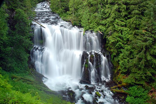
Before heading up to Marion Falls, we stopped to see Gooch Falls, which requires a short hike up a logging road and a short hike down an unofficial trail to the cliff above the falls. (You can find directions here.)
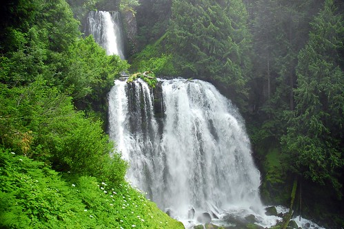
Gooch Falls is IMPRESSIVE. I’m amazed that such a beautiful and easily-accessed waterfall doesn’t have an official trail and signs. So much water was roaring over the falls that the spray rose up in huge amounts to shower us and our cameras with water. We were pretty wet when we were done, as were our cameras. With frequent lens-wiping, I managed to get a good shot.
I also took a video.
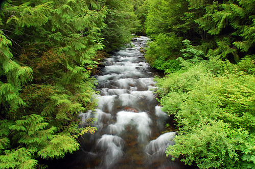
Before heading up to the Marion Falls trailhead, we went back down the road a short ways to filter water, since our campground didn’t have any. After doing so, I took a photo of lovely Marion Creek from the bridge that spans it.
And then we were finally ready to hit the trail. There were quite a few cars at the Marion Lake trailhead, including a large group of Youth Corps folks. But for all the cars at the trailhead, we ran into only a few people on the trail, most of them being backpackers on their way out.
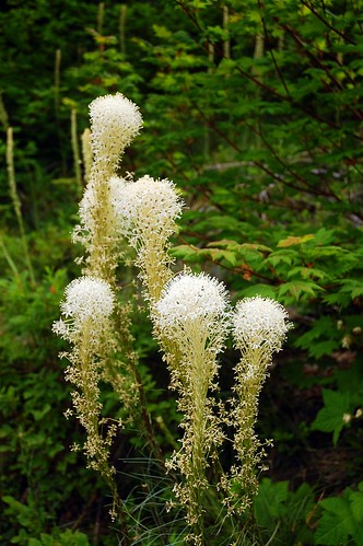
We ate lunch at Lake Ann, where we saw some nice beargrass.
At the junction after Lake Ann, we took the right fork, and a short while later reached the obvious (but unmarked) trail heading off to the right. We took this up and over a hump and down to Marion Creek. I had gotten this far last year, but lost the trail then. Turns out you go downstream from there. The “trail” is faint, pretty much non-existent. But there is barely any undergrowth so it’s easy walking.
You soon reach a viewpoint at the top of Marion Falls, but you can’t really see much. So we took a trail to the right which heads steeply down the hill near the creek and waterfall. This is VERY steep. I fell once, my feet slipping out from under me. Thanks to my hiking poles I caught myself and just got a few scrapes.
We reached a spot where we could see the upper tier of Marion Falls. Greg went all the way out beyond the green vegetation you see here in the foreground, but it’s steep and wet out there, so I took my picture from back at the edge of the trees. There was A LOT of spray.
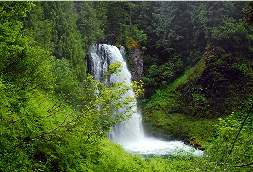
I was a little reluctant due to the steep difficult trail, but Greg convinced me that going further down was worth it to see the bottom tier. So we made our way further down and it was indeed worth it.
See the video here.
As with the upper tier, there was a lot of spray here, maybe even more than above. It was pretty damn impressive. Once again, I can’t believe the Forest Service hasn’t built an official trail out here.
I’m glad I had Greg to show me where this was. Even if I had been able to find the top-of-the-falls viewpoint last year, I’m not sure I would have been up to tackling the steep scramble trail down for a better view of the falls. It was nice to get a gander at this impressive waterfall! If you go here, be careful. The trail to the viewpoint is fine, but the scramble trail can be difficult.
We didn’t go to Marion Lake, although we wanted to. We had planned on fitting both this and the Pamelia Lake hike into one day and it was already 3:00 when we got back to the main trail. So we booked it out to the car and headed over to Pamelia Lake.


